固定对话栏 | 支持 | GIS 词典
A 到 Z 的 GIS |
探索这份相关指南,其中包含更新的术语和图形,并由 Esri 的 GIS 词典团队协作开发。
了解更多关于 A 到 Z 的 GIS 知识
GIS 字典
浏览字典
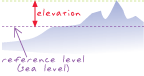
高程
URL 已复制
共享 URL
[大地测量,测量值]
距参考表面或基准面(通常是指海平面)以上或以下的点或对象的垂直距离。 高程通常是指土地的垂直高度。
另请参阅
垂直大地基准面
高度