方法
ArcGIS Pro で使用するために新しい NTv2 地理座標系変換およびグリッド ファイルをインストールする
サマリー
NTv2 (National Transformation version 2) は、標準のバイナリ グリッド シフト (.GSB) ファイル形式です。 一部の NTv2 地理座標系変換では、ArcGIS Pro と一緒にインストールされていないファイルが必要です。 地理座標系変換ファイルとグリッド ファイルは、My Esri の ArcGIS Coordinate System Data ソフトウェア コンポーネントを使用してダウンロードおよびインストールできます。 ファイルをダウンロードする方法については、「ArcGIS Pro: 座標系の補足ファイルのインストール」をご参照ください。
ただし、ArcGIS Pro では、ライセンスの制限により、特定のグリッドベースの地理座標系変換のグリッド ファイルは配布されません。 カナダの場合、地理座標系変換およびグリッド ファイルは Esri ソフトウェアのインストールに含まれておらず、カナダの州ではこれらのファイルに対して課金するため、My Esri からダウンロードすることはできません。 ユーザーは、各州政府または Esri Canada からこれらのファイルを取得できます。 NTv2 地理座標系変換およびグリッド ファイルを取得する方法については、「FAQ: カナダの測地基準系変換グリッドはどこで入手できますか?」をご参照ください。
この記事では、NTv2 地理座標系変換およびグリッド ファイルを ArcGIS Pro にインストールするワークフローについて説明します。
手順
- ファイル エクスプローラーを開き、ntv2 フォルダーを開きます。
C:\Program Files\ArcGIS\Pro\Resources\pedata\ntv2
- ntv2 フォルダーで、新しいフォルダーを作成し、座標系変換が適用される国の名前でフォルダーに名前を付けます。 この例では、カナダのフォルダーが作成されています。
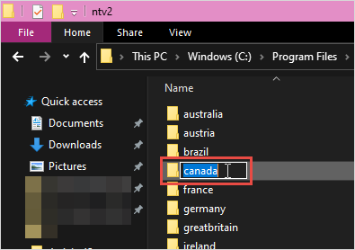
Note:
The new folder name must be a single word and in lowercase letters. No spaces are permitted in the folder name.
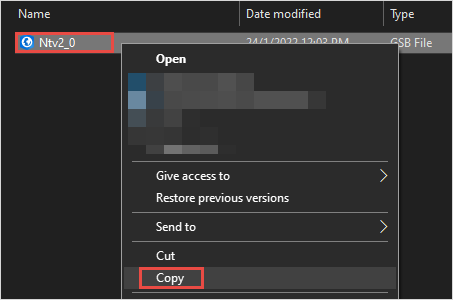
- NTv2 地理座標系変換ファイルをコピーして、フォルダーに貼り付けます。
- ArcGIS Pro プロジェクトを開きます。
- ジオプロセシング ウィンドウで、カスタム地理座標系変換の作成ツールを検索してクリックします。 手順については、「ArcGIS Pro: ジオプロセシング ウィンドウでのツールの実行」をご参照ください。
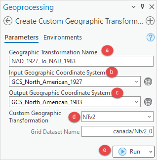
- カスタム地理座標系変換の作成ウィンドウで、パラメーターを次のように構成します。
- 地理座標系変換名で、座標系変換の名前を指定します。 座標系変換名にはアンダースコアを使用できますが、スペースを含めることはできません。 座標系変換名の形式は「Input_GCS_To_Output_GCS」です。
- 入力地理座標系で座標系の選択
 をクリックし、座標系ウィンドウで変換前の地理座標系を選択します。
 - 出力地理座標系で座標系の選択
 をクリックし、座標系ウィンドウで最終的な地理座標系を選択します。
Note:
To determine the best geographic transformation for data, refer to How To: Select the correct geographic (datum) transformation when projecting between datums for more information. The list includes an alphabetical list of all transformations that are available for each version of the software, the published accuracy of the transformation (in meters), and both a text description, and coordinates, describing the extent to which that transformation can be used. If the data falls outside the area the transformation is defined for, the data is not transformed.
- カスタム地理座標系変換ドロップダウン リストから NTv2 を選択します。
- 実行をクリックします。 カスタム座標系変換ファイルは、C:\Users\<user profile>\AppData\Roaming\Esri\ArcGISPro\ArcToolbox\CustomTransformations に作成されます。
- 新しい座標系変換を使用するには、ArcGIS Pro を終了して再起動します
Note:
The NTv2 geographic transformation and grid files are not removed when ArcGIS Pro is uninstalled.
顧客の座標系変換ファイルは個々の Windows の「ユーザー」フォルダー パスに作成されるため、新しい地理座標系変換は、座標系変換を作成したユーザーのみが使用できます。コンピューター上の他のユーザーやオフィス内の他のコンピューターからこのファイルにアクセスできるようにするには、次の操作を行います。
- カスタム座標系変換ファイルのコピーを作成します。
- 新しいユーザーの AppData\Roaming フォルダーに、次のように CustomTransformations という名前の新しいフォルダーを作成します。
C:\Users\<username>\AppData\Roaming\ESRI\ArcGISPro\ArcToolbox\CustomTransformations
- カスタム座標系変換ファイルを新しいユーザーの CustomTransformations フォルダーに貼り付けます。
記事 ID: 000029167
AI によるサポートを受ける
Esri サポート AI チャットボットを使用して問題を迅速に解決します。


関連情報
このトピックについてさらに調べる
Search for related information
Find training related to this topic
Explore ideas and give feedback
ArcGIS エキスパートのサポートを受ける
今すぐチャットを開始