PROBLEM
Georeferencing tools are disabled in ArcGIS Pro
Description
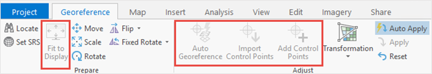
When attempting to georeference a raster dataset in a map using georeferencing tools on the Georeference tab, some tools such as the Auto Georeference, Import Control Points, and Add Control Points tools are disabled, as demonstrated in the image below.
Cause
When adding a raster dataset to a map with a predefined coordinate system, the dataset automatically displays using the same coordinate system as the map. This issue occurs when the raster dataset’s defined coordinate system is different from the map’s coordinate system, causing it to be projected on-the-fly. Thus, the raster dataset is used for display and query purposes only, and the actual dataset cannot be modified. Refer to ArcGIS Blog: Projection on the fly and geographic transformations for more information.
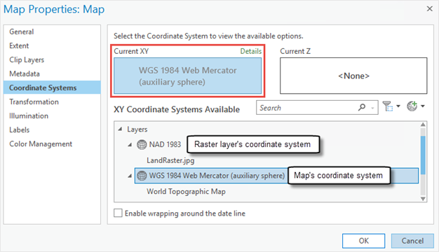
For example, the image below shows the raster layer draws on the map’s coordinate system, WGS 1984 Web Mercator (auxiliary sphere) even though it is stored under NAD 1983.
Solution or Workaround
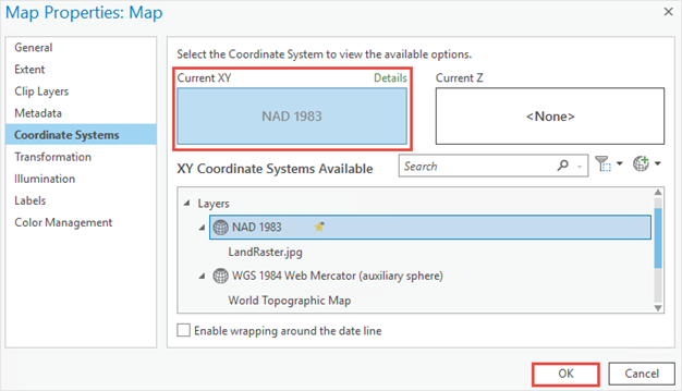
To resolve the issue, set the map’s coordinate system to be the same as the raster layer in ArcGIS Pro.
Open the ArcGIS Pro project containing the raster layer, and set the coordinate system of the map based on the raster layer’s coordinate system. Refer to ArcGIS Pro: Specify the coordinate systems of maps and scenes for steps to do this.
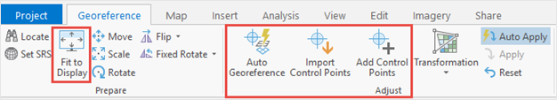
The image below shows the enabled georeferencing tools in the Prepare and Adjust groups in ArcGIS Pro.
Article ID: 000025915
- ArcGIS Pro 2 8 x
- ArcGIS Pro 2 7 x
- ArcGIS Pro 2 x
Get support with AI
Resolve your issue quickly with the Esri Support AI Chatbot.


Related Information
Discover more on this topic
Search for related information
Find training related to this topic
Explore ideas and give feedback
Get help from ArcGIS experts
Start chatting now