PROBLEM
X and Y coordinates display at incorrect locations in ArcGIS Pro
Description
In ArcGIS Pro, X and Y coordinates added to a basemap from a table using the XY Table To Points tool are displayed at incorrect locations.
Cause
The following describe the possible causes:
- The geographic coordinate system of the map extent does not match that of the output feature class. This causes the points to deviate from the intended location.
- A projected coordinate system is used for the output feature class instead of a geographic coordinate system. When a projected coordinate system is used, the X and Y coordinates from the table are expressed using linear measurements instead of decimal degrees.
Solution or Workaround
Use the same geographic coordinate system as the map extent when creating output feature classes from XY coordinates. Then, use the Project tool to change the coordinate system back to the data's original coordinate system.
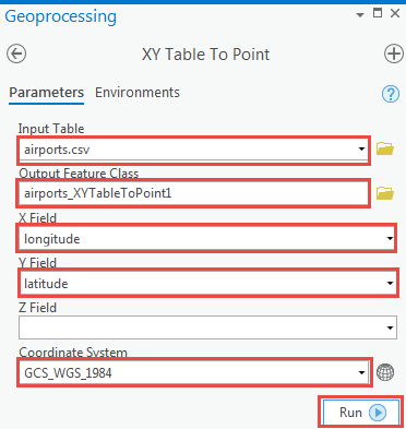
- In ArcGIS Pro, on the Contents pane, right-click the table containing the X and Y coordinates, and click Display XY Data.
- Configure the XY Table To Point parameters as follows:
- For Input Table, select the table containing the X and Y coordinates to be added as a feature class on the map from the drop-down menu.
- For Output Feature Class, specify a name and save the location for the output feature class.
- For X Field, select the field in the input table containing the X coordinates or longitude from the drop-down menu.
- For Y Field, select the field in the input table containing the Y coordinates or latitude from the drop-down menu.
- For Coordinate System, select GCS_WGS_1984 from the drop-down menu.
- Click Run.
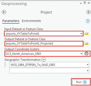
- On the Geoprocessing pane, navigate to Toolboxes > Data Management Tools > Projections and Transformations, and click Project.
- Configure the Project parameters as follows:
- For Input Dataset or Feature Class, select the feature class to be projected from the drop-down menu.
- For Output Dataset or Feature Class, specify a name and save the location for the output feature class from the drop-down menu.
- For Output Coordinate System, specify the original coordinate system of the data.
- Click Run.
The point feature class is displayed in the correct location.
Article ID: 000022862
- ArcGIS Pro 2 x
Get support with AI
Resolve your issue quickly with the Esri Support AI Chatbot.


Related Information
Discover more on this topic
Search for related information
Find training related to this topic
Explore ideas and give feedback
Get help from ArcGIS experts
Start chatting now