ERROR
The layer type is not supported in runtime content. Failed to execute (CreateMobileMapPackage)
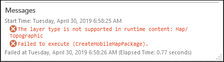
Error Message
A mobile map package (.mmpk) can be created using the Create Mobile Map Package tool to include maps and basemaps along with other referenced data sources to be used by other mobile applications, such as Explorer for ArcGIS and Navigator for ArcGIS, for offline mapping and navigation. However, creating a mobile map package containing an Esri basemap (for example, World Imagery and Topography) in ArcGIS Pro returns the following error:
Error:
The layer type is not supported in runtime content: Map/<basemap name>
Failed to execute (CreateMobileMapPackage).
Cause
This is a known limitation. The Create Mobile Map Package tool does not support Esri basemaps or services to be included in a mobile map package. It only supports local, file-based vector data (including shapefiles and file geodatabases) and tile packages (.tpk) of imagery and other raster data.
Solution or Workaround
As a workaround, take the Esri basemap offline by creating a tile package containing a clipped portion of the Esri basemap using the Download Map function. Create a mobile map package using the created tile package.
Note:
The workflow provided in this article is for ArcGIS Pro 2.2 and later versions only.
- In ArcGIS Pro, create a new project. Refer to Create a project for steps to do this.
- Add the desired data to the project.
- In the Map tab, click the Basemap button in the Layer group, and select the desired basemap.
- Zoom to the extent of the area of interest or the desired extent of the basemap to include in the mobile map package.
- Take the basemap offline by creating a tile package using the Download Map function. For steps to do this, refer to Take tile layers offline. The map tile package layer is added to the map when the export process completes.
- Make sure the coordinate system of the map tile package matches the coordinate system of the map.
- In the Contents pane, right-click Map > Properties.
- In the Map Properties dialog box, click Coordinate Systems. Ensure the coordinate system of the Current XY matches the map tile package coordinate system.
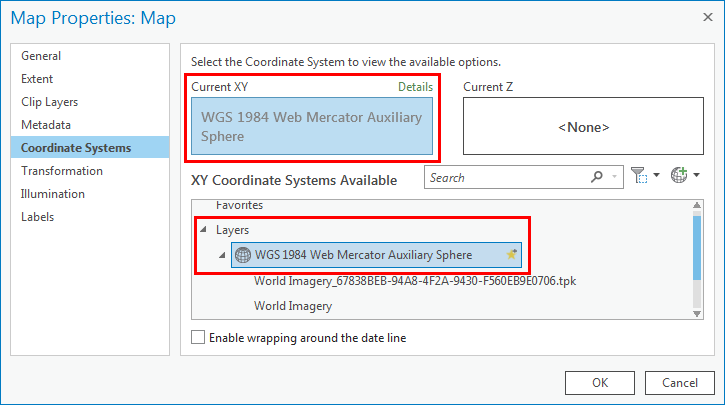
Note:
Custom applications built with the runtime and Esri Apps, such as Explorer for ArcGIS, will not display tile package layers if the coordinate system is not the same as the map.
- Remove the Esri basemap from the map. In the Contents pane, right-click the basemap, and click Remove.
- Run the Create Mobile Map Package tool. This creates a mobile map package containing a clipped portion of the Esri basemap that can be added to the ArcGIS Online content and viewed offline with other mobile applications, such as Explorer for ArcGIS.
Article ID:000019878
- ArcGIS Pro 2 x
Get help from ArcGIS experts
Download the Esri Support App
Related Information
Discover more on this topic
Search for related information
Find training related to this topic
Explore ideas and give feedback