PROBLEM
Point features in an overlapping buffer area are calculated twice in ArcGIS Online
Description
Point features in an overlapping buffer area are calculated twice, creating a false result of the overall point count within the region.
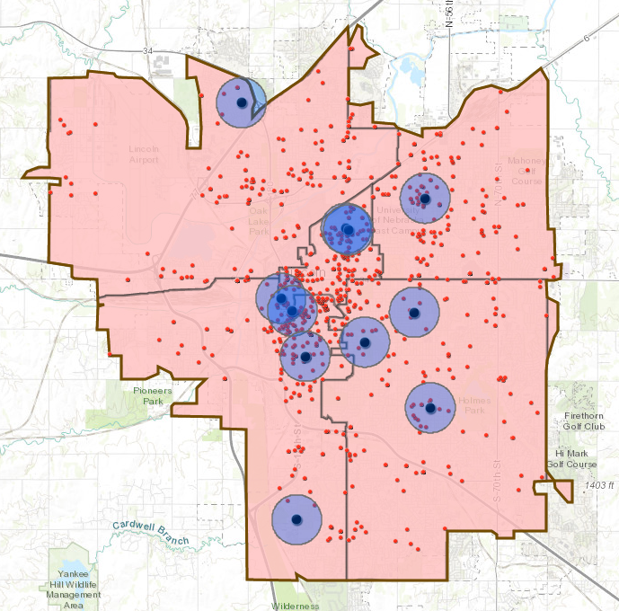
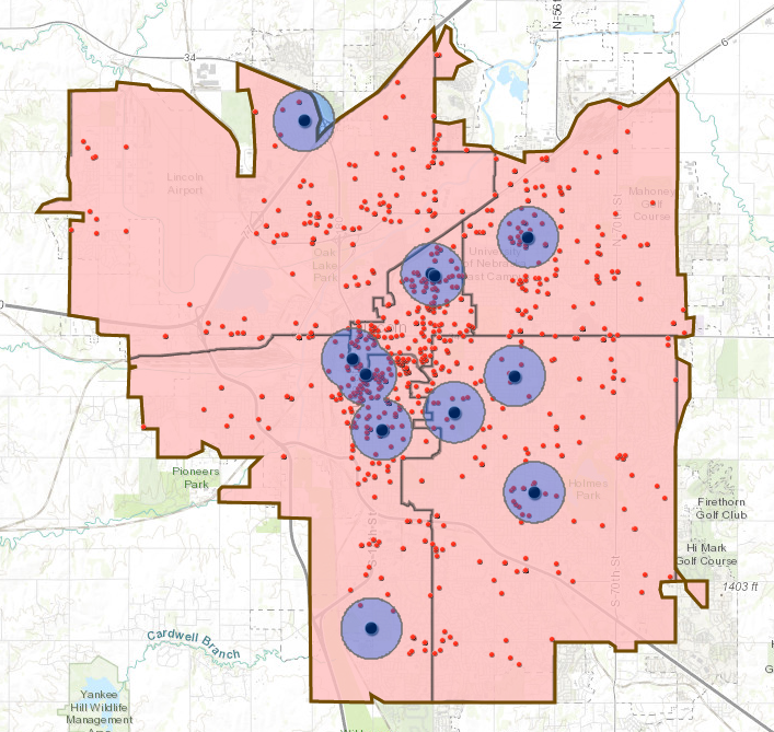
The image below shows the distribution of crime occurrences and police stations in Lincoln, Nebraska. The total number of crime incidents within 0.5 miles radius of police stations is determined by creating an overlap buffer of 0.5 miles radius from each police station.
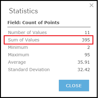
Running the Summarize Within analysis on the overlapping buffer area, and the Statistics command from the attribute table on the recently created Summarize Within layer, calculates the total number of point features to be 395.
Cause
This problem occurs because the default overlap buffer is used instead of the dissolve buffer. The overlap buffer keeps the common area, and so calculates the point features in the overlapping area twice. In contrast, the dissolve buffer combines the common area into a single feature, and so calculates the point features in the overlapping area once.
Solution or Workaround
There are two ways to ensure the point features in the overlapping buffer area are only calculated once, that is, using the Dissolve buffer type or using the Dissolve Boundaries tool.
Note:
The Create Buffers and Dissolve Boundaries analyses use 1 credit per 1000 features for each analysis. For more information on credit usage, refer to ArcGIS Online Help: Understand credits.
Using the Dissolve Buffer type
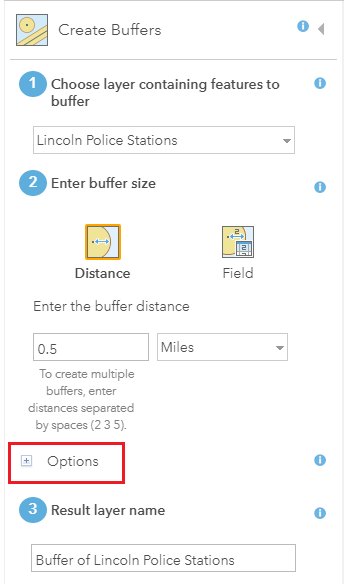
- In ArcGIS Online, navigate to Analysis > Use Proximity > Create Buffers. This opens the Create Buffers pane.
- For Choose layer containing features to buffer, specify the layer containing features to buffer.
- For Enter buffer size, specify the buffer distance and unit.
- Click the add (+) symbol next to Options.
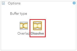
- Select Buffer type as Dissolve.
- Click RUN ANALYSIS.
The image below shows the dissolve buffer area within 0.5 miles radius of each police station.
- Navigate to Analysis > Summarize Data > Summarize Within. This opens the Summarize Within pane.
- For Choose the polygon layer, specify the dissolve buffer layer.
- For Choose a layer to summarize, specify the point layer to be calculated.
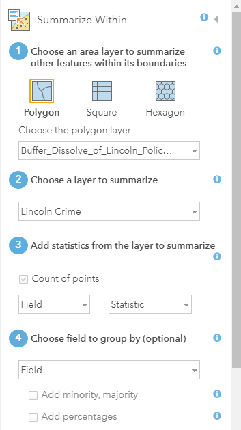
- Click RUN ANALYSIS.
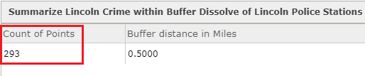
- In the Content tab, hover over the output layer of the Summarize Within analysis, and click the Show Table button. In the attribute table, the total point count within the buffer area is 293.
This option is suitable for a project with existing overlapping buffers.
- In ArcGIS Online, navigate to Analysis > Manage Data > Dissolve Boundaries. This opens the Dissolve Boundaries pane.
- For Choose area layer where boundaries will be dissolved, select the overlapping buffer layer to be dissolved.
- For Choose dissolve method, maintain the default Areas that overlap or are adjacent option.
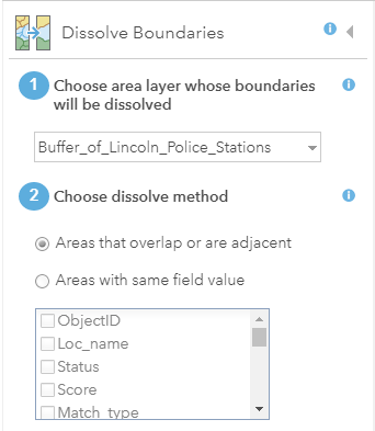
- Click RUN ANALYSIS.
- Use the Summarize Within analysis to calculate the total point count. The output generated using the Dissolve Boundaries analysis is the same as the output generated using the Dissolve Buffer type.
Note:
To create a single restricted buffer zone for buffer zones from multiple layers (for example, combining police station, library, and school buffers), navigate to Analysis > Manage Data > Overlay Layers. In the Choose overlay method step, select the Union option. Proceed with the Dissolve Boundaries analysis to create a single buffer zone. For more information, refer to Analytics: Are liquor stores too close to schools, libraries, and parks?
Article ID: 000018799
- ArcGIS Online
Get support with AI
Resolve your issue quickly with the Esri Support AI Chatbot.


Related Information
Discover more on this topic
Search for related information
Find training related to this topic
Explore ideas and give feedback
Get help from ArcGIS experts
Start chatting now