HOW TO
View the World Imagery basemap metadata in ArcGIS Pro
Summary
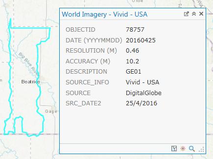
The World Imagery basemap contains high-resolution satellite and aerial imagery of the world. The information of the imagery basemap, such as the acquisition date, resolution, and source can be viewed in the metadata via pop-ups when clicking a desired area on the map.
The instructions provided describe how to view the World Imagery basemap metadata in ArcGIS Pro.
Note:
To view the World Imagery basemap metadata in ArcGIS Desktop, refer to the following document: FAQ: Is it possible to determine the date of an image from the World Imagery basemap?

To view the World Imagery basemap metadata in ArcGIS Online, refer to the following document: ArcGIS Blog: Learning more about the World Imagery basemap
Procedure
- In ArcGIS Pro, open a new blank project.
- In the Insert tab, click New Map in the Project group. A new map is opened and added to the project.
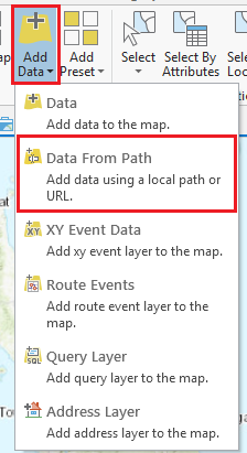
- In the Map tab, navigate to the Layer group > Add Data > Data From Path.
- In the Add Data From Path dialog box, paste the following URL in Path:
https://services.arcgisonline.com/ArcGIS/rest/services/World_Imagery/MapServer/0

- Click Add to add the World Imagery basemap.
- Zoom in and click the desired area to view the metadata.
Article ID: 000018129
Software:
- ArcGIS Pro
Get support with AI
Resolve your issue quickly with the Esri Support AI Chatbot.


Related Information
Discover more on this topic
Search for related information
Find training related to this topic
Explore ideas and give feedback
Get help from ArcGIS experts
Start chatting now