PROBLEM
Unable to move a feature class to a feature dataset in ArcGIS Pro
Description
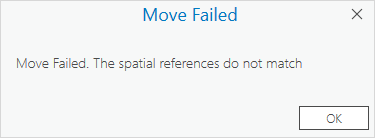
In ArcGIS Pro, when moving a feature class from a geodatabase to a feature dataset, the following message is returned.
Error:
Move Failed. The spatial references do not match
Cause
The feature class layer and destination feature dataset have different coordinate systems, resolutions, and tolerance values. The spatial reference includes the X and Y coordinates, the XY Resolution, the XY Tolerance, as well as the Z and M resolution and tolerance values. For more information on the coordinate properties in ArcGIS Pro, refer to ArcGIS Pro: The properties of a spatial reference.
Solution or Workaround
Use one of the following options to ensure the feature class has the same spatial reference properties as the feature dataset.
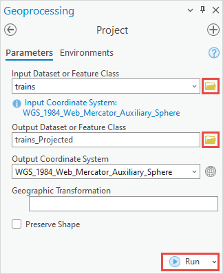
Use the Project tool and select the feature dataset as the output destination
- Open the ArcGIS Pro project.
- On the Analysis tab, in the Geoprocessing group, select Tools.
- In the Geoprocessing pane, search for and click the Project tool.
- On the Parameters tab, for Input Dataset or Feature Class, click Browse
 .
. - In the Input Dataset or Feature Class window, navigate to and click the feature class to be projected. Click OK.
Note:
Alternatively, if the feature class has been added to the map, click the drop-down arrow for Input Dataset or Feature Class in the Geoprocessing pane and select the feature class.
- For Output Dataset or Feature Class, click Browse
 .
. - In the Output Dataset or Feature Class window, navigate to and double-click the destination feature dataset. In this example, the feature dataset is Transportation.
- In the feature dataset container, specify a name for the projected feature class in the Name text box.
- Click Save.

- In the Geoprocessing pane, click Run.
Export the feature class to the feature dataset in the geodatabase
- Open the ArcGIS Pro project.
- Add the feature class to the map.
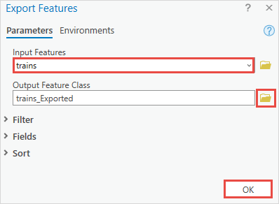
- In the Contents pane, right-click the feature class and navigate to Data > Export Features.
- In the Export Features dialog box, on the Parameters tab, ensure the correct feature class is selected for Input Features.
- For Output Feature Class, click Browse
 .
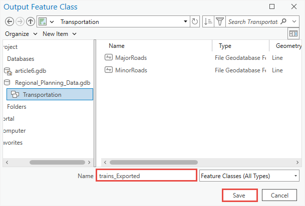
. - In the Output Feature Class window, navigate to and double-click the destination feature dataset.
- In the feature dataset container, specify a name for the exported feature class in the Name text box.
- Click Save.
- In the Export Features dialog box, click OK.
Create a new feature class with the default resolution and tolerance values and a coordinate system imported from the destination feature dataset
Refer to ArcGIS Pro: Correct an invalid spatial reference to set the feature class to the default resolution and tolerance values. In Step 9, browse to the location of the feature dataset to import the coordinate system. The newly created feature class can be moved to the feature dataset.
Article ID: 000032436
- ArcGIS Pro 3 1
- ArcGIS Pro 3 0
- ArcGIS Pro 3 2
Get support with AI
Resolve your issue quickly with the Esri Support AI Chatbot.


Related Information
Discover more on this topic
Search for related information
Find training related to this topic
Explore ideas and give feedback
Get help from ArcGIS experts
Start chatting now