PROBLEM
Unable to create True Orthos from RGB images in ArcGIS Drone2Map
Description
A True Ortho is an orthorectified imagery product fully corrected to display a nadir image. This product is created as a three-band RGB (red, green, and blue) or single-band thermal image in TIFF format, using the project’s coordinate system. In ArcGIS Drone2Map, when using the RGB drone imagery to create a True Ortho product, the camera model fails to compute and returns the following error message:
Error:
ERROR 999999: Something unexpected caused the tool to fail. Contact Esri Technical Support (https://esriurl.com/support) to Report a Bug, and refer to the error help for potential solutions or workarounds.
Failed to execute (ComputeCameraModel).

Cause
This behavior is caused by incorrect use of the camera model's information from the drone during processing of the 2D product. Accurate information is required for the software to properly align the imagery to the elevation surface.
Solution or Workaround
- Open the project in ArcGIS Drone2Map.
- On the Flight Data tab, in the Manage group, click Edit Camera.
- In the Edit Camera Parameters pane, for Camera Source, select Image Metadata from the drop-down list.
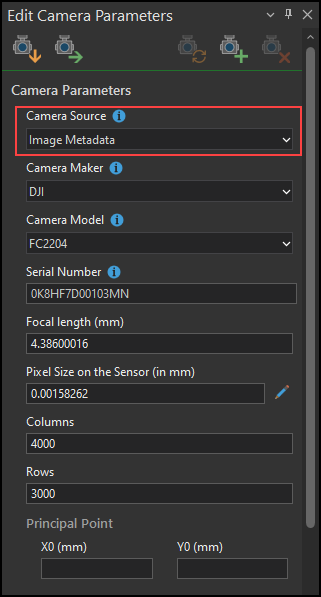
- Click OK.
Note:
The Image Metadata option populates all of the image parameters from the drone, which includes essential information such as the camera model, focal length, and sensor pixel size. Restart the True Orthos processing when the camera parameters are populated. Refer to ArcGIS Drone2Map: Use the 2D Products template for more information.
Article ID: 000034302
- ArcGIS Drone2Map
Get support with AI
Resolve your issue quickly with the Esri Support AI Chatbot.


Related Information
Discover more on this topic
Search for related information
Find training related to this topic
Explore ideas and give feedback
Get help from ArcGIS experts
Start chatting now