PROBLEM
Unable to add a raster dataset in ArcMap or ArcGIS Pro
Description
When adding a raster dataset such as a digital elevation model (DEM) or an Esri GRID to ArcMap or ArcGIS Pro, the following messages are returned respectively.
In ArcMap
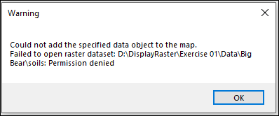
In ArcMap, the error message is followed by a warning message.
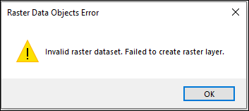
Error:
Invalid raster dataset. Failed to create raster layer.
Warning:
Could not add the specified data object to the map.
Failed to open raster dataset: <file path>: Permission denied
In ArcGIS Pro
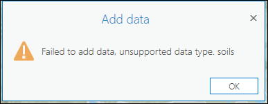
Error:
Failed to add data, unsupported data type. <file>
Cause
The following are known causes for this issue:
- The raster dataset is stored in a location with insufficient read or write permissions, such as a network drive, cloud-synced folder, or a restricted directory.
- The file path or the filename of the raster dataset does not adhere to the ArcGIS filename restrictions. Refer to ArcMap: Name restrictions or ArcGIS Pro: Name restrictions for more information.
- The raster dataset format is not supported, or required supporting files such as .aux, .hdr, or .tfw are missing.
- The raster dataset is corrupted or incomplete, often due to an interrupted or improper download.
Solution or Workaround
Depending on the cause, use one of the options below to resolve the issue.
Save the raster dataset to a local drive
In ArcMap
- Move or save the desired raster dataset to a folder on the local drive, for example (C:).
- Launch ArcMap.
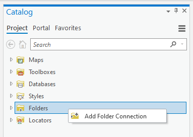
- In the Catalog pane, right-click Folder Connections, and select Connect To Folder.
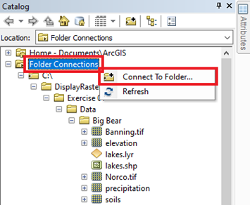
- In the Connect To Folder window, select the new folder location of the raster dataset in Step 1, and click OK.
In ArcGIS Pro
- Move or save the desired raster dataset to a folder on the local drive, for example (C:).
- Launch ArcGIS Pro.
- In the Catalog pane, add a folder connection to access the raster dataset in the local folder. Refer to ArcGIS Pro: Connect to an existing folder for instructions.
Note:
Alternatively, drag the folder from Windows File Explorer, and drop it in the Catalog pane in ArcGIS Pro.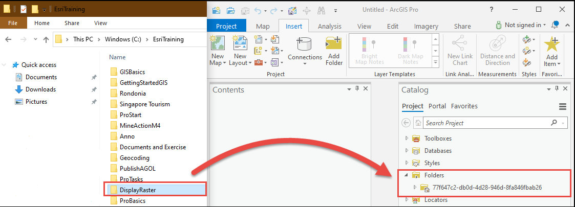
- In the Add Folder Connection window, select the new folder location of the raster dataset in Step 1, and click OK.
- Add the raster dataset to the map. Refer to Steps 1 through 2 in ArcGIS Pro: Add data from a folder for instructions.
Ensure the file path or filename of the raster dataset adheres to the name restrictions
Remove spaces, special characters, or excessively long names from the file path and filename of the raster dataset stored in the local folder. Alternatively, store the raster dataset in a directory with a shorter path length. Refer to ArcGIS Pro: Output raster formats and names or ArcMap: Output raster formats and names for more information.
Verify the raster dataset format and supporting files
Before downloading the raster dataset, ensure the raster format is supported by ArcMap or ArcGIS Pro. Refer to ArcMap: Supported raster dataset file formats or ArcGIS Pro: Raster file formats for more information. After downloading the raster dataset, ensure all required auxiliary and supporting files associated with the raster dataset, such as .aux, .hdr, or world files (.tfw), are present in the same directory as the raster dataset. Avoid renaming individual raster files, as this can break the relationship between the raster dataset and its supporting files. If the raster dataset was previously renamed, ensure all related supporting files are renamed consistently or obtain a new copy of the dataset.
Redownload the raster dataset
Delete the existing raster dataset from the local drive and redownload it from the original or authoritative data provider. Ensure the download is completed successfully without interruption. If the raster dataset is provided in a compressed format, such as .zip or .rar, extract all contents using a reliable extraction tool. After extraction, verify that all raster files and required supporting files are present, then add the newly downloaded raster dataset to ArcMap or ArcGIS Pro. Refer to ArcMap: Adding data to your map or ArcGIS Pro: Add data to a project for more information
Article ID: 000020632
- ArcMap
- ArcGIS Pro
Get support with AI
Resolve your issue quickly with the Esri Support AI Chatbot.


Related Information
Discover more on this topic
Search for related information
Find training related to this topic
Explore ideas and give feedback
Get help from ArcGIS experts
Start chatting now