PROBLEM
The projected coordinate system of a feature layer published from ArcGIS Pro is not retained in ArcGIS Online
Description
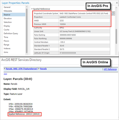
When publishing a feature layer from ArcGIS Pro to ArcGIS Online, the projected coordinate system of the feature layer is not retained and is changed to a different coordinate system.
In this example, the feature layer is projected using the NAD 1983 StatePlane Colorado Central FIPS 0502 (US Feet) coordinate system in ArcGIS Pro. However, the REST endpoint of the feature layer in ArcGIS Online indicates a projection to the NAD 1983 UTM Zone 10N (WKID 26910), as shown in the image below.
Cause
The map’s coordinate system is different from the coordinate system of the feature layer. In ArcGIS Online, layers published from ArcGIS Pro use the map's spatial reference as defined in the map properties. Although ArcGIS Online supports various spatial references, layers added in web maps are dynamically reprojected to align with the coordinate system of Map Viewer. By default, web maps and basemaps in ArcGIS Online use the WGS 1984 Web Mercator coordinate system.
Solution or Workaround
For the feature layer to retain the original projected coordinate system when published to ArcGIS Online, configure the map properties in ArcGIS Pro to match the layer's coordinate system. In ArcGIS Online, add a custom basemap to match the spatial reference of the feature layer.
- Open the ArcGIS Pro project.
- Adjust the coordinate system of the map to match the feature layer.
- In the Contents pane, right-click the map and select Properties.
- In the Map Properties dialog box, click the Coordinate Systems tab.
- Under XY Coordinate Systems Available, expand Layers. Expand a coordinate system heading to view the layers that reference it and select the feature layer. In this example, the feature layer with the NAD 1983 StatePlane Colorado Central FIPS 0502 (US Feet) coordinate system is selected.
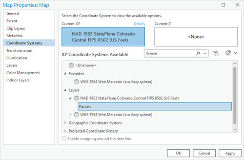
- Click Apply and click OK to close the Map Properties dialog box.
- Publish the feature layer as a web layer to ArcGIS Online. Refer to ArcGIS Pro: Share a web feature layer using the default configuration for further instructions.
- Apply a different coordinate system to the web map by using a basemap with the desired coordinate system.
- In ArcGIS Online, add a basemap with a different coordinate system than the default to Map Viewer. Refer to ArcGIS Online: Use a basemap that is not in the gallery for further instructions.
- Add the published feature layer to the map. Refer to ArcGIS Online: Browse layers for further instructions.
Article ID: 000033827
- ArcGIS Online
- ArcGIS Pro 3 1
- ArcGIS Pro 3 3
- ArcGIS Pro 3 2
Get support with AI
Resolve your issue quickly with the Esri Support AI Chatbot.


Related Information
Discover more on this topic
Search for related information
Find training related to this topic
Explore ideas and give feedback
Get help from ArcGIS experts
Start chatting now