PROBLEM
The Polygon To Centerline tool produces lines with decentered endpoints in ArcGIS Pro
Description
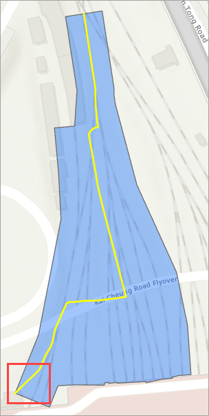
In ArcGIS Pro, when running the Polygon To Centerline tool, the endpoint of the resulting line is decentered within the input polygon. The image below shows the output line in ArcGIS Pro.
Cause
The input polygon has asymmetrical shapes with irregular widths. The Polygon To Centerline tool's output highly depends on the topological integrity of the polygon input and is, therefore, highly sensitive to the geometry. Refer to ArcGIS Pro: Usage for more information. When the polygon has asymmetrical shapes with irregular widths, the tool is unable to maintain an even centerline distribution between the polygon sides, resulting in the centerline drifting toward one side or appearing curved.
Solution or Workaround
The workaround is to simplify the polygon's complex edges using a generalization tool before running the Polygon To Centerline tool.
Note:
In the Contents pane, uncheck or remove the existing Polygon To Centerline output before proceeding with the workflow.
- Open the ArcGIS Pro project.
- Simplify the input polygon using the Simplify Polygon tool.
Note:
This tool requires a Standard or Advanced license.
- On the ribbon, click the Analysis tab. In the Geoprocessing group, click Tools.
- In the Geoprocessing pane, search for and click Simplify Polygon (Cartography Tools).
- In the Simplify Polygon pane, for Input Features, click the drop-down arrow and select the polygon feature layer.
- For Output Feature Class, specify a name. Click Browse and specify a location for the output feature class.
- For Simplification Tolerance, enter the degree of simplification, click the drop-down arrow, and select the unit. Refer to ArcGIS Pro: Parameters for more information. In this example, '10 Meters' is specified.
- Click Run.
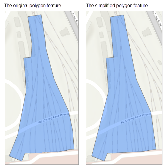
The image below shows the comparison between the original and the simplified polygon features.
- Generate the centerline using the Polygon To Centerline tool.
Note:
This tool requires a Standard or Advanced license with the Production Mapping extension enabled. Refer to ArcGIS Pro: Get started with ArcGIS Production Mapping for more information.
- In the Simplify Polygon pane, click Back
 .
. - In the Geoprocessing pane, search for and click Polygon To Centerline (Topographic Production Tools).
- In the Polygon To Centerline pane, for Input Features, click the drop-down arrow and select the output in Step 1.
- For Output Feature Class, specify a name. Click Browse and specify a location for the output feature class.
- Click Run.
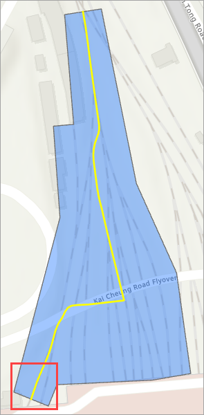
The image below shows the centered endpoint of the resulting line.
Article ID: 000035943
- ArcGIS Pro
Get support with AI
Resolve your issue quickly with the Esri Support AI Chatbot.


Related Information
Discover more on this topic
Search for related information
Find training related to this topic
Explore ideas and give feedback
Get help from ArcGIS experts
Start chatting now