PROBLEM
The Enrich Layer tool generates inaccurate output for a polygon layer in ArcGIS Online Map Viewer
Description
When running the Enrich Layer tool for a polygon layer in ArcGIS Online, the output data in the attribute table is inaccurate compared to the actual data, as the enriched data does not align with the expected values. In some instances, the enriched data is significantly lower than the actual data, approximately 50,000. In this article, a polygon feature layer representing a specific area is enriched with population demographics using the Enrich Layer tool.
Cause
The inaccurate result is caused by voids within the polygon features. Voids occur due to the presence of water bodies, the selection of specific class types, or the exclusion of certain areas during analysis. Data enrichment uses the best available data apportionment method to determine the value of each variable in the map. It employs a Weighted Centroid geographical retrieval methodology to aggregate data for the polygon features. The existence of the voids in the polygon layer leads to inaccuracies in the final data output, as the tool is unable to account for the missing information within voided areas. Refer to Esri Location Data: How data enrichment works for more information.
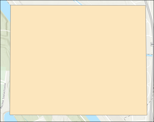
The image below shows a polygon feature with a void across the river area.

Solution or Workaround
To solve this issue, create and digitize a new polygon feature layer without voids based on the existing polygon feature layer. Run the Enrich Layer tool and use the newly created polygon feature layer as the input. Follow the steps outlined below for instructions.
- In ArcGIS Online, create a new hosted polygon feature layer. Refer to ArcGIS Online: Define your own layer for instructions.
- In ArcGIS Online, open the published web map consisting of the original polygon feature layer with voids. Refer to ArcGIS Online: Find and open a map for instructions.
- Add the new feature layer created in Step 1 to the published web map. Refer to ArcGIS Online: Browse layers for instructions.
- Create a new polygon feature in the newly added feature layer to cover the void and the entire area of the existing polygon feature layer. Refer to ArcGIS Online: Add features for instructions.
The image below shows the newly generated polygon feature without void.
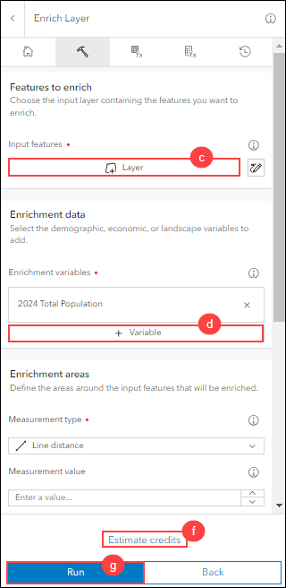
- Enrich the new polygon feature layer using the Enrich Layer tool.
- On the Setting toolbar, click Analysis > Tools.
- In the Tools pane, search for and click Enrich Layer.
- For Input features, click Layer. In the Select layer dialog box, select the new polygon feature layer created in Step 1 and close the dialog box.
- For Enrichment data, click Variable. In the Data Browser window, select the preferred data variable and click Select. In this example, Population is selected.
- For Output name, specify a name.
- Click Estimate credits.
- Click Run.
The image below shows the new attribute table for the polygon feature generated using the Enrich Layer tool.

Article ID: 000033385
- ArcGIS Online
Get support with AI
Resolve your issue quickly with the Esri Support AI Chatbot.


Related Information
Discover more on this topic
Search for related information
Find training related to this topic
Explore ideas and give feedback
Get help from ArcGIS experts
Start chatting now