PROBLEM
Some symbol range classes are not displayed in ArcGIS Pro
Description
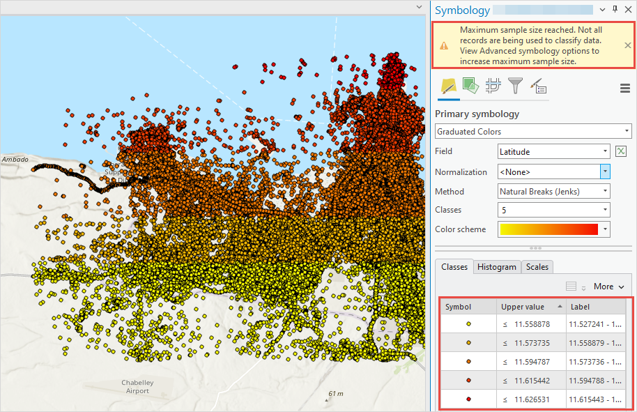
In ArcGIS Pro, when symbolizing a feature layer, some data ranges of symbol classes are not displayed in the map, and the following warning message is returned:
Warning:
Maximum sample size reached. Not all records are being used to classify data. View Advanced symbology options to increase maximum sample size.
The warning message only returns when graduated color symbology, unclassed colors symbology, graduated symbols, bivariate colors symbology, or proportional symbology is selected. In this example, graduated color symbology is used to symbolize the data. The Symbology pane displays five symbol range classes, but only four classes are displayed in the map.
Cause
The data in the feature layer exceeds the maximum sample size used to calculate statistics and class ranges. By default, the maximum sample size is set to 10,000 records.
Solution or Workaround
To solve the issue, increase the maximum sample size to match the data records of the feature layer in ArcGIS Pro.
Note:
Increasing the maximum sample size may affect the performance of the project to render the symbology of the feature layer.
- Open the ArcGIS Pro project.
- In the Contents pane, right-click the feature layer and click Symbology.
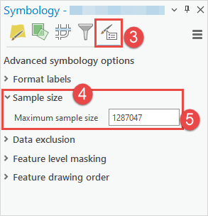
- In the Symbology pane, click Advanced symbology options
 .
. - On the Advanced symbology options tab, expand Sample size.
- For Maximum sample size, specify the preferred maximum sample size and press Enter on the keyboard. Ensure the sample size specified is the same or higher than the number of data records in the feature layer. In this example, the maximum sample size is set to 1,287,047 to match the feature layer’s data records.
Article ID: 000032284
- ArcGIS Pro 3 1
- ArcGIS Pro 3 0
- ArcGIS Pro 3 2
Get support with AI
Resolve your issue quickly with the Esri Support AI Chatbot.


Related Information
Discover more on this topic
Search for related information
Find training related to this topic
Explore ideas and give feedback
Get help from ArcGIS experts
Start chatting now