PROBLEM
Saving a georeferenced raster image returns the raster image to the original location
Description
In ArcGIS Pro, a raster image can be georeferenced to a referenced layer to define its location based on the coordinate system of the map. In some instances, saving the georeferenced raster image returns the raster image to the original location.
Cause
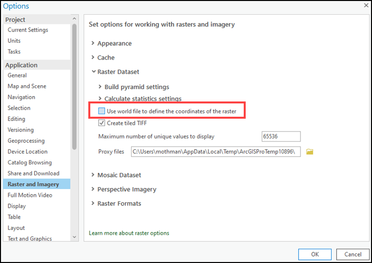
The ‘Use world file to define the coordinates of the raster’ option is enabled in ArcGIS Pro. When the option is enabled, ArcGIS Pro reads the georeferencing information stored in the world file instead of the GeoTIFF file.
Solution or Workaround
Use one of the following options to save a georeferenced raster image successfully in ArcGIS Pro:
Disable the Use world file to define the coordinates of the raster option
In ArcGIS Pro, disable the Use world file to define the coordinates of the raster option to allow ArcGIS Pro to read the georeferencing information of the GeoTIFF file instead. Refer to ArcGIS Pro: Set ArcGIS to read the world file first for more information to do so, and uncheck the Use world file to define the coordinates of the raster check box in Step 5.
Delete the .tfw, tif.aux.xml, and tif.ovr files before georeferencing the raster image
In the local device, delete the associated .tfw, tif.aux.xml, and tif.ovr files in the GeoTIFF folder before georeferencing the raster image in ArcGIS Pro. If the raster image has been georeferenced, remove the raster image from the map, and delete the associated files in the local device.
After deleting the associated files in the GeoTIFF folder, georeference the raster image to the referenced layer in ArcGIS Pro. This option generates new associated .tfw, tif.aux.xml, and tif.ovr files according to the georeferencing information of the raster image.
Article ID: 000027511
- ArcGIS Pro 2 8 x
- ArcGIS Pro 2 7 x
- ArcGIS Pro 2 x
Get support with AI
Resolve your issue quickly with the Esri Support AI Chatbot.


Related Information
Discover more on this topic
Search for related information
Find training related to this topic
Explore ideas and give feedback
Get help from ArcGIS experts
Start chatting now