PROBLEM
The Mosaic To New Raster geoprocessing tool takes much more time than the Mosaic or Workspace to Raster Dataset tools
Description
The geoprocessing tool Mosaic To New Raster creates a new raster dataset and mosaics the input raster into a new raster dataset. The whole workflow is executed in one geoprocessing tool.
Building pyramids is automatically done when mosaicking the input raster into the target raster using the Mosaic geoprocessing tool, however the Mosaic To New Raster tool requires significantly more time to run than the Mosaic tool.
Cause
The Mosaic To New Raster tool generates a new raster without setting the pyramid reference point (origin) of the raster.
In contrast to this, there would be the use of a two-step workflow:
- Create an empty raster dataset as target raster dataset by using geoprocessing tool Create Raster Dataset, where the Origin/Pyramid Reference Point parameter is explicitly set.
- Mosaicking the several input raster datasets into the target raster dataset by using the Mosaic or Workspace To Raster Dataset tool.
Without a pyramid reference point, the process of mosaicking the raster datasets takes significantly longer if pyramids are calculated automatically during the mosaicking process.
With larger amounts of data, it is especially recommended to calculate the pyramids after the mosaicking process was successfully finished.
To check, if a pyramid reference point was set, the raster datasets were generated in an enterprise geodatabase
In the Enterprise Geodatabase repository, the sde.GDB Items table was checked. The GDB_Items table contains a Definition column that contains XML information. The XML tag is present if the raster has a pyramid reference point set, as follows:
<Origin xsi:type=“typens:PointN”>
<X>-5120763.2677228367</X>
</Y>9997963.9429363422</Y>
</Origin>
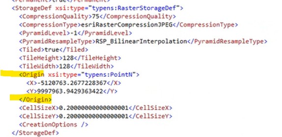
This Origin XML tag is present in the case of a raster created using “Create Raster Dataset”. The XML tag is missing in the case of a raster created using Mosaic To New Raster.
It is possible to delete the automatically filled value for the pyramid reference point in the Create Raster Dataset tool. In this case, the Origin XML tag is also missing in the entry for the raster in the GDB_Items table.
Solution or Workaround
Use the two-step-workflow by using the Create Raster Dataset and Mosaic or the Create Raster Dataset and Workspace To Raster Dataset geoprocessing tools.
Consider another approach to Image management by creating and using a Mosaic dataset instead of mosaicking all the raster datasets into a large single raster dataset.
Article ID: 000035530
- ArcGIS Pro
Get support with AI
Resolve your issue quickly with the Esri Support AI Chatbot.


Related Information
Discover more on this topic
Search for related information
Find training related to this topic
Explore ideas and give feedback
Get help from ArcGIS experts
Start chatting now