PROBLEM
Drone imagery does not align correctly when published to the ArcGIS Enterprise portal
Description
When publishing drone imagery as an image service from ArcGIS Pro or the ArcGIS Enterprise portal, the published service does not display in the correct geographic location in Map Viewer. The same misalignment is observed when accessing the service in ArcGIS Pro. However, when the same imagery is added and viewed in ArcGIS Drone2Map, it displays correctly and aligns to the expected location, as shown in the image below.
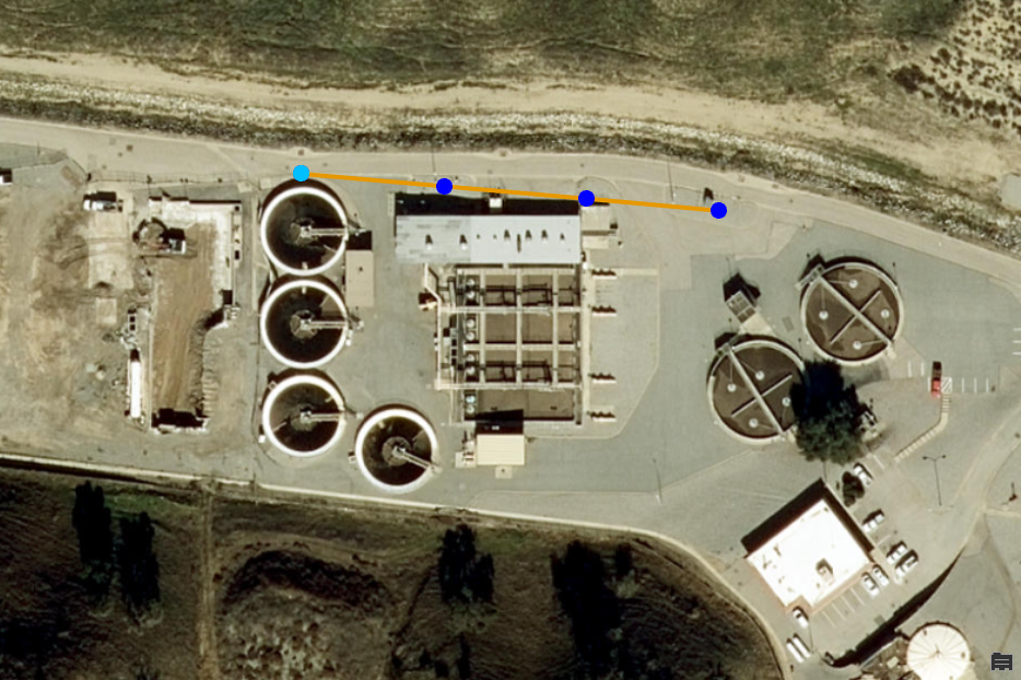
The image below shows the image service located incorrectly in Map Viewer, appearing shifted from the basemap and overlapping the wrong geographic area.
Cause
Drone imagery contains spatial reference information in the EXIF metadata, including focal length, sensor size, and capture location. ArcGIS Pro and the Enterprise portal do not directly utilize EXIF metadata to position imagery when publishing to the Enterprise portal. Instead, they require an XML file that defines the spatial extent and position of the imagery. If the XML file is missing, the imagery cannot be positioned correctly.
Solution or Workaround
Generate and publish True Orthos using ArcGIS Drone2Map
To correctly position drone imagery in the ArcGIS Enterprise portal, generate a True Ortho in ArcGIS Drone2Map. Refer to ArcGIS Drone2Map: Use the 2D Products template for instructions. Generating a True Ortho automatically creates an auxiliary XML file that defines the spatial reference, extent, and positioning of the imagery, which ensures the published service is correctly georeferenced and displays in the expected location in the Enterprise portal.
Once the True Ortho is generated, publish it as an image service directly from ArcGIS Drone2Map to the Enterprise portal. Refer to ArcGIS Drone2Map: Publish your imagery layer for instructions.
Generate and publish an orthomosaic using ArcGIS Pro
In ArcGIS Pro, create an ortho mapping workspace for drone imagery and apply a photogrammetric adjustment with ground control points to generate an orthomosaic. Refer to Imagery Workflows: Create Drone Imagery Products in ArcGIS Pro for instructions.
Once the orthomosaic is created, publish it as an image service to the Enterprise portal. Refer to ArcGIS Pro: Publish an image service for instructions.
Note:
Use the Project Raster tool if the orthomosaic is in a local or unsupported coordinate system. Reprojecting ensures the imagery aligns with organizational basemaps and other spatial datasets in the Enterprise portal.
Note:
Use the Define Projection tool if the defined coordinate system is incorrect.
Article ID: 000037963
- ArcGIS Pro
- Portal for ArcGIS
- ArcGIS Drone2Map
Get support with AI
Resolve your issue quickly with the Esri Support AI Chatbot.


Related Information
Discover more on this topic
Search for related information
Find training related to this topic
Explore ideas and give feedback
Get help from ArcGIS experts
Start chatting now