HOW TO
Snap multiple point features to the nearest line feature in ArcGIS Pro
Summary
In ArcGIS Pro, snapping point features to the nearest line feature is useful for accurate network analysis and proximity calculations. For example, when collecting GPS points on an accessible path corresponding to features along a river, it is necessary to relocate the points to align with a line feature layer representing the river on the map to accurately represent real-world features.
This article describes the workflows to snap multiple point features to the nearest line feature in ArcGIS Pro.
Procedure
Use the Snap tool
Note:
The Snap tool requires an ArcGIS Desktop Standard or Advanced license.
In this workflow, the Snap tool moves points to the nearest edge of a line when point features are within the snap distance, which equals or exceeds the actual distance to the line feature. However, if the snap distance is smaller than the distance from the point to the line, the point does not snap and remains in its original position.
- Open the ArcGIS Pro project.
- On the Analysis tab, in the Geoprocessing group, click Tools.
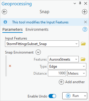
- In the Geoprocessing pane, search for and click Snap (Editing Tools).
- In the Snap pane, on the Parameters tab, for Input Features, click the drop-down menu and select the point feature layer.
- Under Snap Environment, for Features, click the drop-down menu and select the line feature layer.
- For Type, click the drop-down menu and select Edge.
- For Distance, specify the distance in the box and click the drop-down menu to select the distance unit.
Note:
The Snap tool modifies the input data. Refer to ArcGIS Pro: Tools that do not create output datasets for more information. To enable undo, toggle the Enable Undo option in the Snap pane before running the tool.
- Click Run.
Use the Generate Near Table tool to create points snapped to a line
In this workflow, the Generate Near Table tool identifies the nearest line feature for each point feature, and point features are recreated to snap to the nearest line feature.
- Open the ArcGIS Pro project.
- Use the Generate Near Table tool.
- On the Analysis tab, in the Geoprocessing group, click Tools.
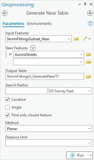
- In the Geoprocessing pane, search for and click Generate Near Table (Analysis Tools).
- In the Generate Near Table pane, for Input Features, click the drop-down menu and select the point feature layer.
- For Near Features, click the drop-down menu and select the line feature layer.
- Specify a name for Output Table and click Browse
 to specify the location of the table.
 - Check the Location and Find only closed feature check boxes.
- Click Run.
- Recreate the point feature layer from the table.
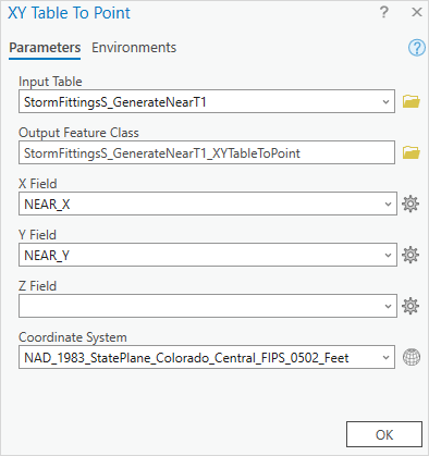
- In the Contents pane, right-click the table and select Create Points From Table > XY Table To Point.
- In the XY Table To Point dialog box, for X Field, click the drop-down menu and select NEAR_X.
- For Y Field, click the drop-down menu and select NEAR_Y.
- For Coordinate System, click the drop-down menu and select the map or feature layer to match the coordinate system.
- Click OK.
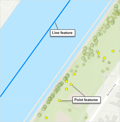
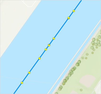
The image below shows the point features snapped to the nearest line feature in ArcGIS Pro.
Article ID: 000033891
- ArcGIS Pro 3 1
- ArcGIS Pro 3 3
- ArcGIS Pro 3 2
Get support with AI
Resolve your issue quickly with the Esri Support AI Chatbot.


Related Information
Discover more on this topic
Search for related information
Find training related to this topic
Explore ideas and give feedback
Get help from ArcGIS experts
Start chatting now