HOW TO
Maintain the input address table order when geocoding in ArcMap
Summary
The ArcGIS Online World Geocoding Service and address locator in ArcMap allows users to geocode a table of addresses into features containing location and spatial geometry. In some cases, the order of addresses in the input address table must be retained in the output geocoded results. For example, if the order of the address table represents the order of stops in which a field worker has traveled to, the geocoded results must be ordered in the same way to indicate the travel path from one point to another.
However, when geocoding a table of addresses in ArcMap, the output geocoded results do not consistently maintain the same order as in the input address table. This is expected behavior when geocoding in ArcMap. The instructions provided describe how to maintain the order of the input address table when geocoding in ArcMap.
Procedure
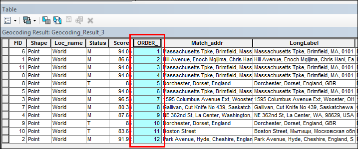
Create a new field with sequential numbers in the input address table, and sort the geocoded results by the sequential numbers field. In this article, the input address table is in a CSV file format.
- In ArcMap, add the CSV file, and export the file to a geodatabase table. Skip this step if the address table used for the geocoding process is a geodatabase table.
- In Table Of Contents, right-click the added address table and click Data > Export.
- In the Export Data dialog box, select a file geodatabase, and set a name for the Output table.
- Click OK. A new geodatabase table is added in Table Of Contents.
- Add a new short integer field to the table and insert sequential numbers in the field. For steps to do this, refer to How To: Create sequential numbers in a field using Python in the Field Calculator.
- Geocode the address table using World Geocoding Service or a built locator. For steps to do this, refer to Geocoding a table of addresses in ArcMap. A new output table is added in Table Of Contents and the geocoded results are displayed on the map.
- Sort the geocoded results in the output table by the field containing the sequential numbers. For steps to do this, refer to Sorting records in a table by one field. The order of the geocoded results in the output table matches the input address table.
Article ID: 000020386
- ArcMap
Get support with AI
Resolve your issue quickly with the Esri Support AI Chatbot.


Related Information
Discover more on this topic
Search for related information
Find training related to this topic
Explore ideas and give feedback
Get help from ArcGIS experts
Start chatting now