HOW TO
Convert multiple CAD data to GeoJSON in ArcGIS Pro
Summary
Computer-aided design (CAD) data is used in a variety of industries, including architecture, engineering, and manufacturing, to create, modify, and analyze models and designs. In ArcGIS Pro, the CAD To Geodatabase tool can be used to merge multiple CAD data into a single dataset. This dataset can then be converted to GeoJSON format using the Features To JSON tool, which enables web maps and web apps to visualize and integrate geographical data. This method simplifies the geometry of features by reducing complexity and file size while retaining necessary spatial information.
This article describes how to convert multiple CAD data to the GeoJSON format in ArcGIS Pro. The image below shows the multiple CAD data used for converting to GeoJSON.

Procedure
- Open the project in ArcGIS Pro.
- Convert the CAD data to a geodatabase feature dataset. Refer to How To: Convert CAD data to GIS data in ArcGIS Pro for instructions.

- Add the output feature dataset from Step 2 to the map. Refer to ArcGIS Pro: Browse to data to add to a map or scene for instructions.
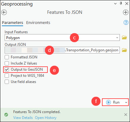
- Convert the feature class to GeoJSON using the Features To JSON tool.
- On the Analysis tab, in the Geoprocessing group, click Tools.
- In the Geoprocessing pane, search for and click Features To JSON (Conversion Tools).
- In the Features To JSON pane, for Input Features, select the feature layer from the drop-down list. In this example, the polygon feature layer is selected.
- For Output JSON, specify a name and location for the output GeoJSON file.
- Check the Output to GeoJSON check box.
- Click Run.
- Repeat Step 4 to convert the remaining feature classes to GeoJSON.
The image below shows the GeoJSON files converted from the multiple CAD data.

Article ID: 000031794
- ArcGIS Pro 3 1
- ArcGIS Pro 3 0
- ArcGIS Pro 3 2
Get support with AI
Resolve your issue quickly with the Esri Support AI Chatbot.


Related Information
Discover more on this topic
Search for related information
Find training related to this topic
Explore ideas and give feedback
Get help from ArcGIS experts
Start chatting now