Frequently asked question
Can reference grid labels be exported to an attribute table in ArcGIS Pro?
Answer
No, reference grid labels in a page layout cannot be exported to the attribute table of a feature layer. Reference grids must be converted to a feature layer before any advanced editing or placement can be done. Reference grid labels based on attribute table values significantly enhance map visualization and data interpretation.
This article outlines a streamlined workflow for creating such labels in the ArcGIS Pro map view. The technique ensures precise feature placement, enables customized labeling using multiple field values, and improves spatial analysis.
However, only graticules, measured grids, and MGRS grids can be converted to feature layers. For more information, refer to ArcGIS Pro: Convert grids to features. Alternatively, a grid index feature layer can be created from a customized fishnet, essentially serving as a reference grid. This layer can then be joined or merged with a feature layer to add the index values to the attribute table.
Note:
This workflow requires a polygon feature layer. If working with enclosed line features, convert them to polygons using the Feature To Polygon tool.
- Open the ArcGIS Pro project.
Note:
For instructions to find and use the geoprocessing tool, refer to ArcGIS Pro: Find a geoprocessing tool.
- Create a fishnet of rectangular cells using the Create Fishnet tool with the following configuration settings.
- In the Create Fishnet pane, for Output Feature Class, specify a name and location.
- For Template Extent, define the desired extent of the fishnet to match the map extent.
- For Number of Rows, specify the total number of fishnet rows.
- For Number of Columns, specify the total number of fishnet columns.
- Define Geometry Type for the output feature layer as Polyline or Polygon.
- Click Run.
- Create polygon index features using the Grid Index Features tool with the following configuration settings.
- For Output Feature Class, specify a name and location.
- For Input Features, select the output feature layer from Step 2 in the drop-down list.
- For Number of Rows and Number of Columns, set the same total number of rows and columns as specified in Step 2.
- Check the Start labeling from the Origin check box.
- Click Run.
- Join attributes between the newly created polygon index features and the polygon feature layer using the Spatial Join tool. Select the output feature layer in Step 3 for Target Features and the polygon feature layer for Join Features.
- Create a grid map within the polygon feature layer by merging the output from Step 4 with the polygon feature layer using the Merge tool.
- Display grid map labels based on the attribute table values. For instructions, refer to ArcGIS Pro: Turn on labels.
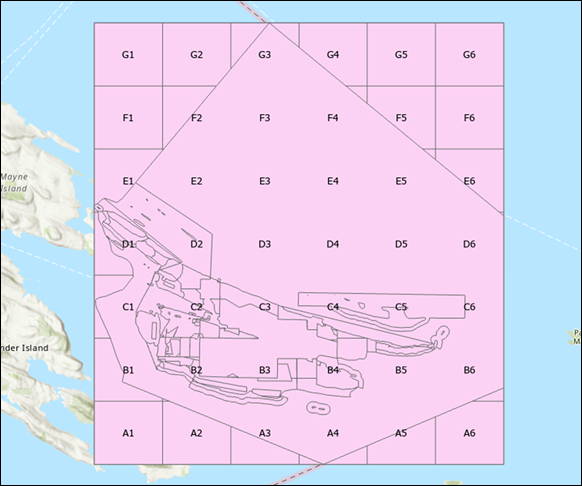
The image below shows the attribute-based reference grid labels displayed on the map.
Article ID: 000035178
- ArcGIS Pro
Get support with AI
Resolve your issue quickly with the Esri Support AI Chatbot.


Related Information
Discover more on this topic
Search for related information
Find training related to this topic
Explore ideas and give feedback
Get help from ArcGIS experts
Start chatting now