Frequently asked question
Can different geometry features be merged into a feature class?
No, features of different spatial representations (point, line, and polygon) cannot be merged into a single feature class. The same geometry type for features must be used when merging datasets into a feature class. However, different, and multiple features can be combined for other purposes such as visualization, exporting features into one file, or creating a buffer for line and point features and joining the feature class to the polygon feature class. The workarounds provided are alternatives to combine the features without placing them into a feature class or changing the line or point feature into a buffer polygon.
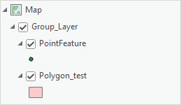
Combine the features into a group layer
In the Contents pane, group the different feature classes into a group layer for display purposes. Refer to ArcGIS Pro: Create a group layer for further instructions.
Export the features as a KML file
Combine the different features into a group layer and export it as a KML file using the Layer To KML (Conversion) tool.
- Open the ArcGIS Pro project.
- Group the features into a group layer. Refer to ArcGIS Pro: Create a group layer for further instructions.
- Export the created group layer as a KML file.
- On the Analysis tab, in the Geoprocessing group, click Tools.
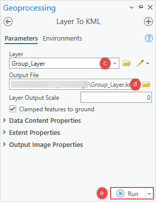
- In the Geoprocessing pane, search for and click the Layer To KML tool.
- In the Layer To KML pane, on the Parameters tab, select the group layer from the Layer drop-down list.
- In the Output File field, click Browse
 to specify a name and file location for the output.
 - Click Run.
Create a buffer and combine it with the polygon feature class
Convert the line or point features into buffer polygons and combine them with the polygon feature class using the Append (Data Management) tool.
Note:
This workflow only applies to line and point features that are combined with polygon features.
- Open the ArcGIS Pro project.
- Create a buffer for the line or point features.
- On the Analysis tab, in the Geoprocessing group, click Tools.
- In the Geoprocessing pane, search for and click the Buffer tool.
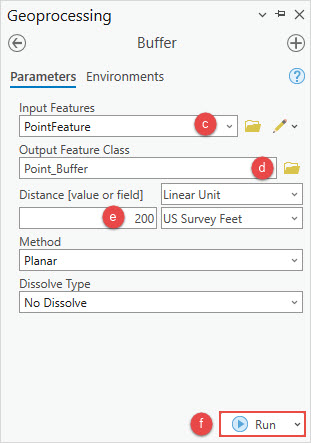
- In the Buffer pane, on the Parameters tab, select the point or line feature layer from the Input Features drop-down list.
- For Output Feature Class, click Browse
 to specify a name and file location for the output.
 - For Distance, specify the distance of the buffer. Refer to ArcGIS Pro: Parameters for more information.
- Click Run.
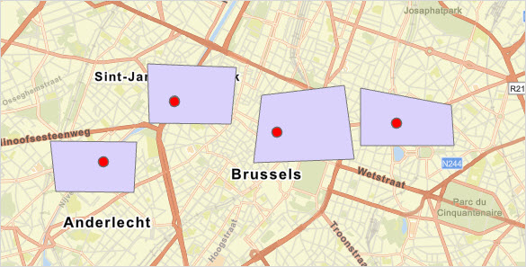
The map shows the buffer polygons (red) converted from point features above the polygon feature (purple).
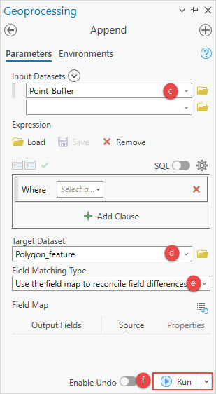
- Append the buffer output feature class to the polygon feature class.
- On the Analysis tab, in the Geoprocessing group, click Tools.
- In the Geoprocessing pane, search for and click Append.
- In the Append pane, on the Parameters tab, select the buffer output layer from the Input Datasets drop-down list.
- For Target Dataset, select the polygon layer from the drop-down list.
- For Field Matching Type, select the desired option from the drop-down list depending on the schema type. Refer to ArcGIS Pro: Parameters for more information.
- Click Run.
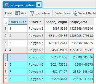
The attribute table displays the buffer polygon data appended to the polygon feature, combining the buffer feature class with the polygon feature class.
Article ID: 000031065
- ArcGIS Pro 3 1
- ArcGIS Pro 3 0
Get support with AI
Resolve your issue quickly with the Esri Support AI Chatbot.


Related Information
Discover more on this topic
Search for related information
Find training related to this topic
Explore ideas and give feedback
Get help from ArcGIS experts
Start chatting now