ERROR
Failed to open delta database
Error Message
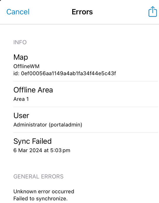
When performing a sync operation on an offline web map that contains referenced feature services from ArcGIS Field Maps, the sync operation fails with the following error message, as shown in the image below:
Sync failed
Unknown error occurred
Failed to synchronize.
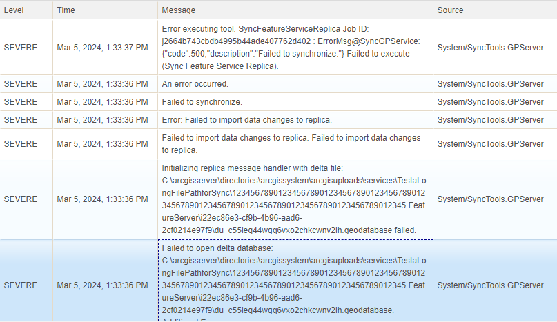
The following errors are seen in the ArcGIS Server logs at the same time, and also shown in the image below:
Error executing tool. SyncFeatureServiceReplica Job ID: jb6349327154443c0a152e0b9ff88a071 : ErrorMsg@SyncGPService:{"code":500,"description":"Failed to synchronize."} Failed to execute (Sync Feature Service Replica).
Initializing replica message handler with delta file: C:\arcgisserver\directories\arcgissystem\arcgisuploads\services\1234567890123456789012345678901234567890\123456789012345678901234567890123456789012345678901234567890123456789012345678.FeatureServer\ibd6c491e-2ad0-43ba-9bba-8c02fb072a73\du_5g4bcmb7zfrelasu6io3oioy2d.geodatabase failed
Failed to open delta database: C:\arcgisserver\directories\arcgissystem\arcgisuploads\services\1234567890123456789012345678901234567890\123456789012345678901234567890123456789012345678901234567890123456789012345678.FeatureServer\ibd6c491e-2ad0-43ba-9bba-8c02fb072a73\du_5g4bcmb7zfrelasu6io3oioy2d.geodatabase. Additional Error:
Cause
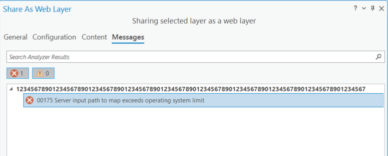
When sharing a web feature layer from ArcGIS Pro to ArcGIS Enterprise, the analyser checks if length of the server input path to map exceeds the operating system file path limit of 260 characters.
In the image below, an error has been returned in the Share As Web Layer window:
00175 Server input path to map exceeds operating system limit
When sharing a sync-enabled web feature layer, the check does not take into account the file length of the delta database that is created when performing a sync operation. If the file length of the database exceeds 260 characters, the sync operation fails.
ArcGIS software is developed and certified to support file system path names with a maximum path length of 260 characters, as defined by MAX_PATH.
Note:
With the Microsoft release of the Windows 10 Anniversary Update, version 1607, it is possible to extend the 260-character limit for NTFS paths. While this is an opt-in behavior of the Windows 10 Anniversary Update, doing so can result in unexpected behavior in ArcGIS and is not supported or recommended.
Solution or Workaround
Republish the web feature layer with a shorter name and update the web map to reference the new feature layer.
Article ID: 000032154
- ArcGIS Pro
- ArcGIS Enterprise
- ArcGIS Field Maps Android
- ArcGIS Field Maps iOS
Get support with AI
Resolve your issue quickly with the Esri Support AI Chatbot.


Related Information
Discover more on this topic
Search for related information
Find training related to this topic
Explore ideas and give feedback
Get help from ArcGIS experts
Start chatting now