A to Z GIS | Explore this related guide, featuring updated terms and graphics and developed in coordination with Esri’s GIS Dictionary team.
Learn more about A to Z GIS
GIS Dictionary
The GIS Dictionary provides definitions for GIS terms related to operations such as analysis, GIS modeling and web-based GIS, cartography, and Esri software.
Browse dictionary
raster
URL copiedShare URL
[data architecture,geography]
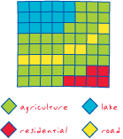
A fundamental data structure consisting of a matrix of equally sized cells, or pixels, arranged in rows and columns, and composed of single or multiple bands. Each cell represents a location on the earth's surface and contains a numeric value that represents a particular attribute or phenomenon, such as temperature at a particular height or depth, elevation, or image brightness value. Groups of cells that share the same cell value represent the same geographic feature.