A to Z GIS | Explore this related guide, featuring updated terms and graphics and developed in coordination with Esri’s GIS Dictionary team.
Learn more about A to Z GIS
GIS Dictionary
Browse dictionary
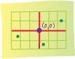
planar coordinate system
URL copiedShare URL
[coordinate systems]
A two-dimensional measurement system that locates features on a plane based on their distance from an origin (0,0) along two perpendicular axes.