A to Z GIS | Explore this related guide, featuring updated terms and graphics and developed in coordination with Esri’s GIS Dictionary team.
Learn more about A to Z GIS
GIS Dictionary
Browse dictionary
illumination
URL copiedShare URL
[physics]
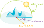
The light incident on a surface or object, either natural or artificial, as determined by the surface's slope and aspect and by the light source's azimuth and altitude.