A to Z GIS | Explore this related guide, featuring updated terms and graphics and developed in coordination with Esri’s GIS Dictionary team.
Learn more about A to Z GIS
GIS Dictionary
Browse dictionary
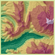
hypsometric tinting
URL copiedShare URL
[visualization techniques]
A method of adding color between contour lines to illustrate changes in elevation depth. Each color represents a different range of elevation. Also called layer tinting or hypsometric coloring.