操作方法
操作方法:诊断 ArcMap 打印或导出问题
摘要
When printing or exporting from ArcMap, the software creates a Windows enhanced metafile (*.EMF) of the layout or data view. Once the EMF file has been created, ArcMap sends it to the printer engine or export driver selected for the conversion to the final output.
If a problem is experienced with printing or exporting from ArcMap, narrow down where in the output process the problem occurs by verifying that the map is written correctly to EMF.
过程
Export the map to EMF in ArcMap and visually evaluate the EMF on screen to make sure it is correct.
Note:
It is highly recommended to use ArcGIS Pro for printing and exporting, especially when experiencing issues caused by the limitations of the ArcMap display engine. More specifically, ArcGIS Pro is not restricted by the graphical device interface (GDI) limitations that some users experience in ArcMap.

For example, transparency is natively supported in ArcGIS Pro, preventing the rasterization of layers. Additionally, ArcGIS Pro supports transparency in layout elements.
Note:
ArcGIS Pro does not support exporting Adobe Illustrator files; it is recommended to export using PDF or SVG instead. Also, because ArcGIS Pro does not use the Windows GDI, font substitution or fallback does not occur in ArcGIS Pro. Boxes may appear if using characters unsupported by the chosen font.
- Navigate to File > Export Map.
- Click the Save as type drop-down and select EMF. Click Save or OK.
- Insert the EMF as a picture into an empty ArcMap document. Navigate to Insert > Picture. Browse to the location disk where the EMF is saved, and click OK.
- Evaluate the resulting image.
- If the EMF is correct, the problem exists in either the printer or exporter driver, in the printer itself, or the application reading the exported file.
- If the EMF is incorrect, the problem exists within ArcMap, usually in converting the elements drawn in the map to the EMF format.
- If the EMF appears low quality or is hard to see, use the appropriate zoom-in tools:
- Layout view: Layout Zoom In/Zoom out
- Data view: Zoom In/Zoom Out
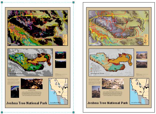
The image above on the right is an example map in Layout view in ArcMap. The image on the left is the inserted EMF picture of the same map. Its inferior quality is due to the way Windows drawing works with EMF files. After zooming into the picture on the left (using the Layout Zoom In tool because the picture was inserted in Layout View) the quality is better and the image looks as expected.when looking at the image as if it were actual size.
文章 ID:000002993
从 ArcGIS 专家处获得帮助
下载 Esri 支持应用程序
相关信息
发现关于本主题的更多内容
Search for related information
Find training related to this topic
Explore ideas and give feedback