操作方法
问题:“近邻分析”工具与“测量”工具返回的结果不同
描述
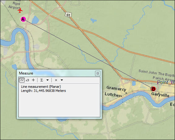
当使用“近邻分析”工具计算给定要素与另一个图层或要素类中最接近的要素之间的距离时,与使用“测量”工具测量相同要素之间的距离相比,返回的结果是不同的。
以下是使用“近邻分析”工具和“测量”工具计算要素 A 和要素 B 之间距离时返回结果的示例。 在下图中,使用“近邻分析”工具测量的 A 点和 B 点之间的距离为 32,031.192086 米,而使用“测量”工具测量的相同距离为 31,445.96838 米。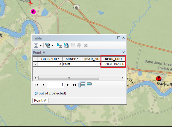
原因
差异的发生是由于数据集和数据框之间使用的坐标系不同所致。 “近邻分析”工具依赖于输入数据集的坐标系,而“测量”工具则依赖于数据框的坐标系。
解决方案或解决方法
要确保“近邻分析”工具返回与“测量”工具相同的距离,数据集和数据框使用的坐标系必须相同。根据数据框或数据集是否具有正确的坐标系,使用以下选项之一来解决此问题:将数据集坐标系与数据框坐标系匹配
对于数据框具有正确坐标系的情况,使用投影工具将数据集的坐标系与数据框坐标系匹配:
- 在目录窗口中,导航至数据管理工具 > 投影和变换 > 投影。
- 选择数据集作为输入数据集或要素类。输入坐标系参数将自动设置为数据集的原始坐标系。
- 设置输出数据集或要素类的名称和位置。
- 在输出坐标系中,浏览查找要分配给输出数据集的数据框坐标系。
- 在地理变换参数中,默认情况下会自动选择变换。 要选择其他变换,请单击下拉箭头,然后选择坐标系的合适地理变换。 仅当需要地理或基准面变换时,才会显示下拉列表。
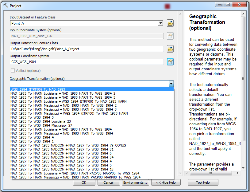
- 选中保留形状复选框,确保输出要素在新投影中准确定位。 仅当涉及地理变换或基准面变换时,此选项才可用。
- 为最大偏移偏差参数设置一个值,控制投影要素可从其投影位置偏移的最大距离。
- 单击确定。
将数据框坐标系与数据集坐标系匹配
对于数据集具有正确坐标系的情况,请更改数据框的坐标系:更改数据框的坐标系。
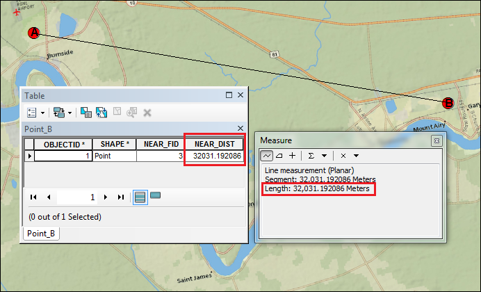
下图显示了当数据集和数据框使用相同的坐标系时,使用这两个工具测量两点之间距离的结果示例。 两个工具显示相同的距离。
Note:
In cases where both the dataset and data frame have the wrong coordinate system, use the same steps to change the coordinate system of the dataset and data frame to the most accurate coordinate system. Refer to the following document to determine which coordinate system is the most suitable for a dataset: How To: Select a suitable map projection or coordinate system.
文章 ID: 000014513
获得人工智能支持
使用 Esri Support AI Chatbot 快速解决您的问题。


相关信息
发现关于本主题的更多内容
Search for related information
Find training related to this topic
Explore ideas and give feedback
获取来自 ArcGIS 专家的帮助
立即开始聊天