操作方法
操作方法:在 ArcGIS Pro 中分割与面边界相交的折线要素
摘要
This article describes two methods to split lines intersecting polygon boundaries. The first option splits lines at polygon boundaries while retaining all the lines and geometry of the original feature class. The second option only includes split line segments overlapping the polygons.
过程
Note:
These tools require an Advanced ArcGIS Pro license.
Split lines at intersecting points
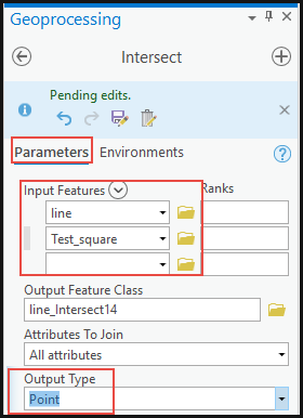
- Identify the points where the polygon boundaries intersect the lines using the Intersect tool.
- In ArcGIS Pro, navigate to Analysis > Tools.
- In the Geoprocessing pane, search for the Intersect tool.

- Under Parameters, select the line and polygon layers for Input Features, and specify the location for the Output Feature Class.
- For Output Type, select Point. Click Run.
- Split the lines at the intersecting points using the Split Line at Point tool.
- In the Geoprocessing pane, search for the Split Line at Point tool.
- Under Parameters, select the line layer for Input Features.
- For Point Features, select Intersect from the drop-down list.
- Specify the new layer name and location for the Output Feature Class.
- For this example, use 0.1 Meters for Search Radius. Click Run.

Split the lines outside the polygon boundaries using the Intersect tool
Note:
Use this method if there is no Advanced license in ArcGIS Pro.
- In ArcGIS Pro, navigate to Analysis > Tools.
- In the Geoprocessing pane, search for the Intersect tool.
- Under Parameters, select the polygon and line layers for Input Features, and specify the location for the Output Feature Class.
- For Output Type, select Line. Click Run.
The following image shows the split lines outside the polygon boundary and only the line overlapping the polygon intact.

Note:
For this method, the lines outside the polygon boundaries are not included in the output.
文章 ID: 000026247
获得人工智能支持
使用 Esri Support AI Chatbot 快速解决您的问题。


相关信息
发现关于本主题的更多内容
Search for related information
Find training related to this topic
Explore ideas and give feedback
获取来自 ArcGIS 专家的帮助
立即开始聊天