操作方法
操作方法:将多个 KML 图层转换为 shapefile
摘要
KML is an XML-based file format for displaying information in a geographic context. While KML information can be drawn in many Earth-based browsers (including ArcGIS Earth and ArcGIS Pro), there are limitations when using them for GIS analysis.
This article describes the method to combine multiple KML layers into a single, usable shapefile to allow advanced GIS analysis on the features within.
过程
- Use the Batch tool to convert KML files.
- In ArcGIS Pro, navigate to Analysis > Tools.
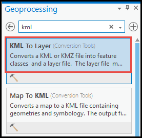
- In the Geoprocessing pane, search for KML To Layer in the search box.
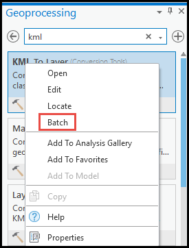
- Right-click the KML To Layer tool, and select Batch.
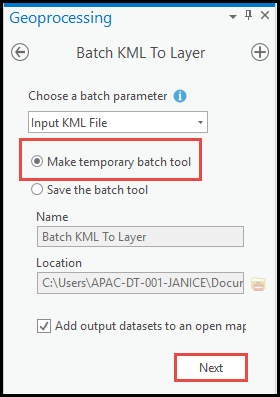
- In the Batch KML To Layer pane, under Choose a batch parameter, select the Make temporary batch tool option.
- Use the default details for Name and Location. Click Next.
- Under Parameters, select all the KML layers for Batch Input KML File, and specify the location for Output Location. Click Run.

Note:
For the Batch Input KML File tool to work, do not remove %NAME% from Output Data Name.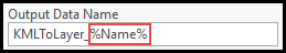
- Use the Merge tool to combine the converted shapefiles.
- In ArcGIS Pro, navigate to Analysis > Tools.
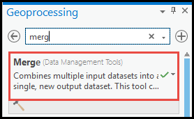
- In the Geoprocessing pane, search for Merge in the search box. Select the tool.
- In the Merge pane, under Parameters, select the shapefiles converted from the Batch Input KML File tool.
- Select the output location for Output Dataset. Click Run.
Note:
Ensure the selected layers contain the same geometry type (for example, merge all the polylines layers only).
文章 ID: 000026382
获得人工智能支持
使用 Esri Support AI Chatbot 快速解决您的问题。


相关信息
发现关于本主题的更多内容
Search for related information
Find training related to this topic
Explore ideas and give feedback
获取来自 ArcGIS 专家的帮助
立即开始聊天