操作方法
操作方法:使用 ArcGIS Pro 将栅格数据集转换为 XYZ 表格
摘要
Several software packages can import data from an XYZ format. This article provides instructions to convert a raster dataset into an XYZ table with ArcGIS Pro.
Note:
This process requires the Spatial Analyst license.
过程
- Open ArcGIS Pro and add the raster dataset.
- Find the Sample tool. Refer to ArcGIS Pro: Find a geoprocessing tool for more information.
- In the Geoprocessing pane, select the desired raster dataset for Input rasters.
- Select the raster dataset again in the Input location raster or point features field. Ensure Resampling technique is set to Nearest.
- Specify Output table.
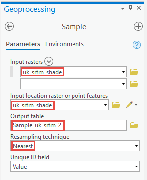
- Click Run.
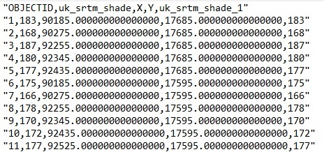
- Once the geoprocessing is complete, right-click the new table. Click Open.
- Export the table and save it with the .txt extension. Refer to ArcGIS Pro: Export tables for more information.
The output text file is in the OID, Z, X, Y format. The image below shows the output file.
文章 ID: 000023278
获得人工智能支持
使用 Esri Support AI Chatbot 快速解决您的问题。


相关信息
发现关于本主题的更多内容
Search for related information
Find training related to this topic
Explore ideas and give feedback
获取来自 ArcGIS 专家的帮助
立即开始聊天