操作方法
操作方法:在 ArcGIS Pro 中计算多面体要素的体积
摘要
In ArcGIS Pro, it is possible to create multipatch features, and calculate the volume of enclosed multipatch features using the Add Z Information tool. This article describes the workflow to calculate the volume of enclosed multipatch features.
过程
- Open the ArcGIS Pro project.
- Ensure the multipatch layer is projected in a Projected Coordinate System. To check the layer's coordinate system, refer to the following steps:
- On the Contents pane, right-click the layer, and click Properties.
- In the Layer Properties window, click the Source tab, and expand the Spatial Reference group.
Note:
The data must be projected in a Projected Coordinate System because volumes are calculated based on linear units of measurement. If the data is in a Geographic Coordinate System, the volumes cannot be calculated based on angular units of measurement.
- If the multipatch layer is projected in a Geographic Coordinate System, project the layer to a Projected Coordinate System using the Project tool.
- On the top ribbon, click the Analysis tab > Tools.
- In the Geoprocessing pane, search for Project (Data Management) and click it. The Project window opens.
- In the Project window, click Parameters.
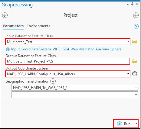
- Click the drop-down menu of Input Dataset or Feature Class, and select the multipatch layer. In this example, the layer is Multipatch_Test.
- For Output Dataset or Feature Class, specify a name for the output layer and its location. In this example, the output name is Multipatch_Test_Project_PCS.
- For Output Coordinate System, select a Projected Coordinate System for the multipatch layer under Projected Coordinate System in the Coordinate System window. In this example, NAD 1983 HARN Contiguous USA Albers is selected.
- Click Run.
- Calculate the volume of the multipatch features using the Add Z Information tool.
- In the Geoprocessing pane, search for Add Z Information (3D Analyst) and click it. The Add Z Information window opens.
- In the Add Z Information window, click Parameters.
- For Input Features, select the multipatch layer projected in the Projected Coordinate System. In this example, the layer is Multipatch_Test_Project_PCS.
- For Output Property, check the Volume check box.
- Click Run.

The following image shows the multipatch layer attribute table with the calculated volume of multipatch features in the Volume field.

文章 ID: 000026288
获得人工智能支持
使用 Esri Support AI Chatbot 快速解决您的问题。


相关信息
发现关于本主题的更多内容
Search for related information
Find training related to this topic
Explore ideas and give feedback
获取来自 ArcGIS 专家的帮助
立即开始聊天