操作方法
错误:基础 DBMS 错误 [[Microsoft][SQL Native Client 10.0][Server] 将浮点型转换为数据类型数字的算术溢出错误
描述
在使用 SQL Server 并涉及到将 shapefile 导入或加载到企业级地理数据库的特定工作流中,如果被加载的数据中存在 DOUBLE 类型字段,则可能会返回以下错误:
Error:
Underlying DBMS error {{Microsoft}{SQL Native Client 10.0}{Server}Arithmetic overflow error converting float to data type numeric.} {{<shapefile name>}
原因
此错误是由于 SQL Server 加载或转换 FLOAT 或 DOUBLE 类型的数据字段的方式造成的,尤其是在字段精度较低的情况下。 这些规则在 shapefile 数据结构中不受支持,因此,如果存在的数据超过将数据加载到 SQL Server 时施加的精度或比例限制,则会返回上述错误。
Note:
Precision refers to the maximum total number of decimal digits that are stored, both to the left and right of the decimal point. The precision must have a value between 1, to the maximum precision of 38. The default precision in SQL Server is set to 18. This limit can be set higher (ex: 500) in ArcCatalog; however, the DBMS limit of 38 is maintained as the highest number storage possible. For more information, please review the Microsoft documentation in the Related Information section below.
解决方案或解决方法
手动编辑或提高企业级要素类的精度级别,适应正在加载的数据。
- 在企业级地理数据库或 SDE 地理数据库中创建一个新要素类,用于加载 shapefile。
- 右键单击数据库或数据集 > 新建 > 要素类。
- 从 shapefile 导入新要素类的坐标系。 此外,将 shapefile 中的字段导入到新要素类中。 单击下一步。
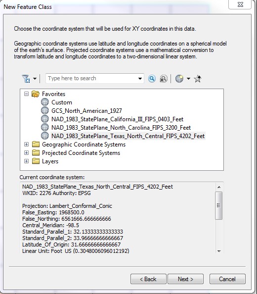
- 接受 tolerance 和 configuration 关键字,除非使用自定义设置。 单击下一步。
- 从 shapefile 导入字段。
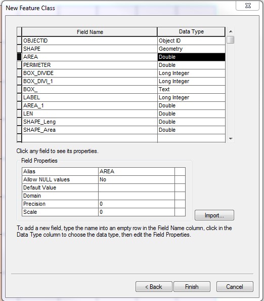
Note:
The default precision values for DOUBLE fields are 0.
- 在字段属性部分,将所有 DOUBLE 字段的精度值更改为数据所需的最大值(最大为 38)。
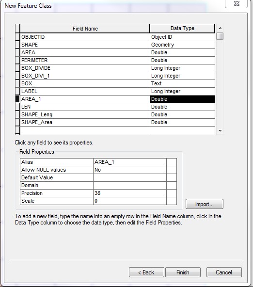
- 更新精度值后,单击完成。
- 右键单击内容列表中新创建的要素类。 选择加载 > 加载数据。
- 在输入数据中引用 shapefile,然后单击添加,列出要加载的源数据。 对其余部分使用默认设置,然后继续加载数据。
文章 ID: 000013811
获得人工智能支持
使用 Esri Support AI Chatbot 快速解决您的问题。


相关信息
发现关于本主题的更多内容
Search for related information
Find training related to this topic
Explore ideas and give feedback
获取来自 ArcGIS 专家的帮助
立即开始聊天