固定对话栏 | 支持 | GIS 词典
A 到 Z 的 GIS |
探索这份相关指南,其中包含更新的术语和图形,并由 Esri 的 GIS 词典团队协作开发。
了解更多关于 A 到 Z 的 GIS 知识
GIS 字典
浏览字典
变换
URL 已复制
共享 URL
[数据转换]
在 GIS 中转换或更改数据以集成不同数据类型、改进可视化或者提供分析框架的过程。 变换可以指坐标变换、几何变换、拓扑变换、图像变换、属性变换或网络变换。
[数据转换]
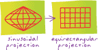
将地图或影像坐标从一个系统转换到另一个系统的过程,通常通过平移、旋转、重设比例、倾斜或投影来完成。
另请参阅
属性变换
坐标变换
几何变换
图像转换
网络转型
拓扑变换