固定对话栏 | 支持 | GIS 词典
A 到 Z 的 GIS |
探索这份相关指南,其中包含更新的术语和图形,并由 Esri 的 GIS 词典团队协作开发。
了解更多关于 A 到 Z 的 GIS 知识
GIS 字典
浏览字典
TLM
URL 已复制
共享 URL
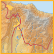
[专题制图,地理]
地形线地图 (Topographic Line Map)
的首字母缩略词。 使用线轮廓显示地球表面的高程和凹陷的地图。 地形线地图可用于描绘地形、高程、基础设施、水文和植被。
另请参阅
地形图