固定对话栏 | 支持 | GIS 词典
A 到 Z 的 GIS |
探索这份相关指南,其中包含更新的术语和图形,并由 Esri 的 GIS 词典团队协作开发。
了解更多关于 A 到 Z 的 GIS 知识
GIS 字典
浏览字典
分辨率
URL 已复制
共享 URL
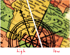
[地图设计,测量值]
地图用于描绘地理要素位置和形状的细节。 地图比例越大,分辨率越高。 随着比例减小,分辨率降低,要素边界必然会变得平滑、简化或不显示;例如,较小区域可能只显示为点。
[影像处理]
栅格数据中每个像元或像素的尺寸,表示地面覆盖的区域。 通常与空间分辨率互换使用。
[影像处理,测量值]
两个显示元素之间的最小间距,以每英寸点数、每行像素数或每毫米行数表示。
[空间分析]
要素类中两个坐标值间的最小容许间隔。 空间参考可以包括 x、y、z 和 m 分辨率值。 分辨率值的倒数之前称为精度或比例值。
另请参阅
像元
dpi
细节层次
小数位数
空间分辨率