固定对话栏 | 支持 | GIS 词典
A 到 Z 的 GIS |
探索这份相关指南,其中包含更新的术语和图形,并由 Esri 的 GIS 词典团队协作开发。
了解更多关于 A 到 Z 的 GIS 知识
GIS 字典
浏览字典
平面坐标系
URL 已复制
共享 URL
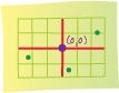
[坐标系]
二维测量系统,根据距离原点 (0,0) 的距离(沿两条互相垂直的轴)来定位平面上的要素。
另请参阅
坐标系