固定对话栏 | 支持 | GIS 词典
A 到 Z 的 GIS |
探索这份相关指南,其中包含更新的术语和图形,并由 Esri 的 GIS 词典团队协作开发。
了解更多关于 A 到 Z 的 GIS 知识
GIS 字典
浏览字典
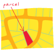
宗地
URL 已复制
共享 URL
[调查]
由一系列连接成多边形的测量直线或曲线进行定义的一块或单位土地。 土地所有权存在一些影响。 通常也称为区域。
[调查]
代表土地或水域面积或体积的一组要素。 在宗地结构中,二维宗地由面要素、线要素和点要素组成。 宗地面表示土地面积,宗地线已启用 COGO 并存储边界测量值,宗地点表示宗地拐角。 宗地可用于表示权利、限制或责任。 宗地也可用于对行政边界或地籍框架进行建模。
另请参阅
地块
计划
PLSS
测量