固定对话栏 | 支持 | GIS 词典
A 到 Z 的 GIS |
探索这份相关指南,其中包含更新的术语和图形,并由 Esri 的 GIS 词典团队协作开发。
了解更多关于 A 到 Z 的 GIS 知识
GIS 字典
浏览字典
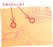
影线
URL 已复制
共享 URL
[符号系统]
地图上的短线,用于表示坡度的方向和陡度。 表示陡坡的影线短而密;表示缓坡的影线则更长、更淡且相距更远。
[符号系统,地理]
用于存储相对地理位置或位置的线性参考中的一系列垂直线或标记符号。 影线或影线图层将按一定间隔显示在要素顶部,其显示间隔以路径测量单位来指定。
另请参阅
路径测量值