固定对话栏 | 支持 | GIS 词典
A 到 Z 的 GIS |
探索这份相关指南,其中包含更新的术语和图形,并由 Esri 的 GIS 词典团队协作开发。
了解更多关于 A 到 Z 的 GIS 知识
GIS 字典
浏览字典
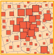
分级符号地图
URL 已复制
共享 URL
[专题制图]
带有符号的地图,这些符号根据其所代表的数据属性的值按比例进行缩放;符号化每个数据值,以显示其在从较小数据值到较大数据值的序列中的位置。 例如,较大的点代表更大的人口密度,较粗的线代表更大的河流。
另请参阅
符号化