固定对话栏 | 支持 | GIS 词典
A 到 Z 的 GIS |
探索这份相关指南,其中包含更新的术语和图形,并由 Esri 的 GIS 词典团队协作开发。
了解更多关于 A 到 Z 的 GIS 知识
GIS 字典
浏览字典
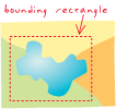
外接矩形
URL 已复制
共享 URL
[制图,地图设计]
与坐标轴对齐并位于地图显示中的矩形,其中包含一个地理要素、一组要素或一个感兴趣区域。 外接矩形由 x 和 y 轴方向上的最大以及最小坐标决定,一般用于代表某一地理区域的位置。
另请参阅
包络矩形