Frequently asked question
How do I manage ArcGIS connections to online resources?
Overview
ArcGIS is a system composed of desktop, server, mobile and online technologies. This system provides GIS and mapping capabilities on a variety of platforms and devices. An increasing amount of functionality is hosted by the online parts of the system. Online refers to both public cloud (ArcGIS Online) and private cloud (ArcGIS Portal) implementations.
Clients connect to these online services to enhance the functionality available on end-user applications. To offer a good user experience, clients must know if they can reach the online services. Since the functionality is typically accessed from the user interface (UI) thread, any delay in accessing the online capabilities can have an adverse effect on the user experience. All the communication to these online services happens through HTTP and HTTPS, which have a number of built-in timeout properties to allow for a variety of connection types. Because of these timeout buffers in the event of no connection, it can take a client several seconds to timeout before finding the connection is not available. Since access to online resources is exercised from various parts of the system, such as File menu, Search window, Catalog tree, and Add Data, there is potential for these timeouts to affect the user experience on the application.
The ArcGIS Connection Utility
To deal with these issues, the ArcGIS Connection utility was created. This utility is used by all ArcGIS Desktop applications to determine their connection status to an ArcGIS Portal or ArcGIS.com. Centralizing this optimizes the number of tests performed. All applications check that the ArcGIS Connection utility is running at startup and then periodically after that.
Note: After the initial test, the tests are run on a lengthening time interval; each test delay is increased by 5 seconds to a maximum of 1 minute. To change the time interval, open the ArcGIS Connection context menu by right-clicking the globe iconin the task bar.
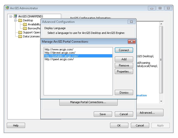
This utility does not test the ability to connect to the internet. This utility tests the ability to connect to an ArcGIS Portal. By default, the ArcGIS Portal used is ArcGIS Online, but this can be configured either by the end user through the ArcGIS Administrator utility, or a system administrator can configure it for a user by configuring a registry key, as shown below:
Registry Key: HKEY_CURRENT_USER\Software\ESRI\ArcGIS Online\SignIn

Registry Value: HomeServerURIFile
The registry value (Data) is the URL of the ArcGIS Portal, specified as a string.
Note:
If set by the administrator, the registry setting cannot be overridden by users via the ArcGIS Administrator utility.
Managing and Testing Portal Connections
The ArcGIS Administrator dialog box is shown below.
To check for a valid connection, the ArcGIS Connection utility attempts to make a HTTP HEAD request of a known resource on the ArcGIS Portal (this is the smallest payload that can be requested from an HTTP server). If the HEAD request is successful, the system is connected, otherwise the system is not connected to the defined ArcGIS Portal. In the event of a failed connection, the UI components of the client application that work with the online resource become disabled, and the user is informed by a tooltip in the taskbar area.
Also in the event of a failed connection, there is a diagnostic tool that gives more information on the connection status. This tool does the following:
- Reports whether or not the application is connected to the portal through a proxy server
- Reports the connection bandwidth to ArcGIS Portal
- Attempts to perform a ping test and network route trace
Note:
These last two tests may provide indeterminate results. This is not a failure; it indicates that the network trace was not able to complete. This can happen due to security settings on the network.

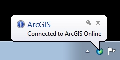
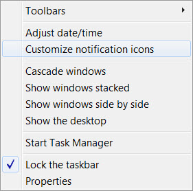
The ArcGIS Connection utility is like any other taskbar utility; it displays an icon that indicates status. A globe symbolizes a good connection, and a globe with a red 'X' symbolizes a bad connection. The Connection utility can also display changes in status through pop-up notifications, wherein the icon displays a tooltip message indicating the status when the cursor hovers over it. This can be configured via standard Windows notification settings. To access these settings, right-click the taskbar clock, and select Customize notification icons.
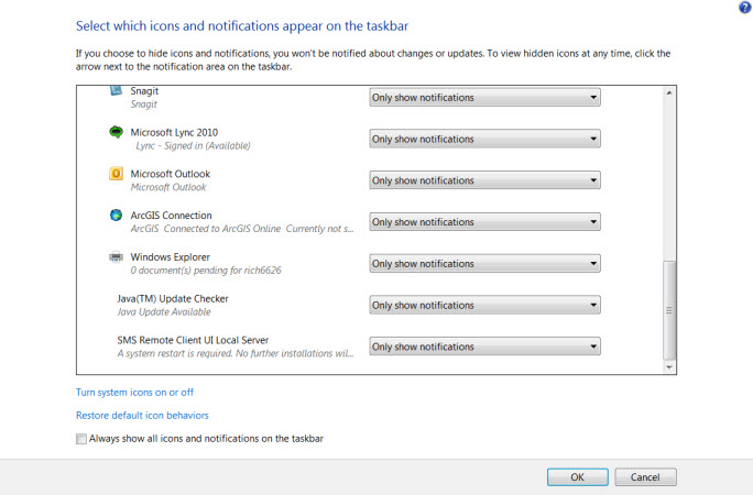
This displays the notification icon manager. Use this interface to configure how Windows displays these notifications.
There is no way to configure the system to turn off this test. In previous versions of ArcGIS for Desktop, attempts were made to access the ArcGIS Portal resources without any central mechanism. This led to poor user experiences as the UI would appear to stop responding for several seconds until the request timed out. With this new mechanism, the access is centralized, limiting the requests. And, since it is in a separate executable, it isolates the UI thread of the desktop application from these timeout situations; providing better user experience.
Article ID: 000011622
- ArcMap
- ArcGIS Online
Get support with AI
Resolve your issue quickly with the Esri Support AI Chatbot.


Discover more on this topic
Search for related information
Find training related to this topic
Explore ideas and give feedback
Get help from ArcGIS experts
Start chatting now