Instrução
Dividir feições de polilinha onde elas interseccionam os limites de polígono no ArcGIS Pro
Resumo
This article describes two methods to split lines intersecting polygon boundaries. The first option splits lines at polygon boundaries while retaining all the lines and geometry of the original feature class. The second option only includes split line segments overlapping the polygons.
Procedimento
Note:
These tools require an Advanced ArcGIS Pro license.
Split lines at intersecting points
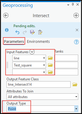
- Identify the points where the polygon boundaries intersect the lines using the Intersect tool.
- In ArcGIS Pro, navigate to Analysis > Tools.
- In the Geoprocessing pane, search for the Intersect tool.

- Under Parameters, select the line and polygon layers for Input Features, and specify the location for the Output Feature Class.
- For Output Type, select Point. Click Run.
- Split the lines at the intersecting points using the Split Line at Point tool.
- In the Geoprocessing pane, search for the Split Line at Point tool.
- Under Parameters, select the line layer for Input Features.
- For Point Features, select Intersect from the drop-down list.
- Specify the new layer name and location for the Output Feature Class.
- For this example, use 0.1 Meters for Search Radius. Click Run.

Split the lines outside the polygon boundaries using the Intersect tool
Note:
Use this method if there is no Advanced license in ArcGIS Pro.
- In ArcGIS Pro, navigate to Analysis > Tools.
- In the Geoprocessing pane, search for the Intersect tool.
- Under Parameters, select the polygon and line layers for Input Features, and specify the location for the Output Feature Class.
- For Output Type, select Line. Click Run.
The following image shows the split lines outside the polygon boundary and only the line overlapping the polygon intact.

Note:
For this method, the lines outside the polygon boundaries are not included in the output.
ID do Artigo: 000026247
Obtenha suporte com IA
Resolva seu problema rapidamente com o chatbot de IA de suporte da Esri.


Informações Relacionadas
Descubra mais sobre este tema
Search for related information
Find training related to this topic
Explore ideas and give feedback
Obtenha ajuda de especialistas do ArcGIS
Comece a conversar agora