Instrução
Calcular o volume das feições de multipatch no ArcGIS Pro
Resumo
In ArcGIS Pro, it is possible to create multipatch features, and calculate the volume of enclosed multipatch features using the Add Z Information tool. This article describes the workflow to calculate the volume of enclosed multipatch features.
Procedimento
- Open the ArcGIS Pro project.
- Ensure the multipatch layer is projected in a Projected Coordinate System. To check the layer's coordinate system, refer to the following steps:
- On the Contents pane, right-click the layer, and click Properties.
- In the Layer Properties window, click the Source tab, and expand the Spatial Reference group.
Note:
The data must be projected in a Projected Coordinate System because volumes are calculated based on linear units of measurement. If the data is in a Geographic Coordinate System, the volumes cannot be calculated based on angular units of measurement.
- If the multipatch layer is projected in a Geographic Coordinate System, project the layer to a Projected Coordinate System using the Project tool.
- On the top ribbon, click the Analysis tab > Tools.
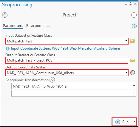
- In the Geoprocessing pane, search for Project (Data Management) and click it. The Project window opens.
- In the Project window, click Parameters.
- Click the drop-down menu of Input Dataset or Feature Class, and select the multipatch layer. In this example, the layer is Multipatch_Test.
- For Output Dataset or Feature Class, specify a name for the output layer and its location. In this example, the output name is Multipatch_Test_Project_PCS.
- For Output Coordinate System, select a Projected Coordinate System for the multipatch layer under Projected Coordinate System in the Coordinate System window. In this example, NAD 1983 HARN Contiguous USA Albers is selected.
- Click Run.
- Calculate the volume of the multipatch features using the Add Z Information tool.
- In the Geoprocessing pane, search for Add Z Information (3D Analyst) and click it. The Add Z Information window opens.
- In the Add Z Information window, click Parameters.
- For Input Features, select the multipatch layer projected in the Projected Coordinate System. In this example, the layer is Multipatch_Test_Project_PCS.
- For Output Property, check the Volume check box.
- Click Run.

The following image shows the multipatch layer attribute table with the calculated volume of multipatch features in the Volume field.

ID do Artigo: 000026288
Obtenha suporte com IA
Resolva seu problema rapidamente com o chatbot de IA de suporte da Esri.


Informações Relacionadas
Descubra mais sobre este tema
Search for related information
Find training related to this topic
Explore ideas and give feedback
Obtenha ajuda de especialistas do ArcGIS
Comece a conversar agora