Instrução
Adicionar anexos grandes a uma feição utilizando o ArcGIS REST Services Directory
Resumo
Dados não geográficos, como documentos, imagens e vídeos, podem ser associados a uma feição em um mapa como anexos. A adição de anexos a uma feição pode ser concluída no ArcGIS Pro, Portal for ArcGIS, ArcGIS Online e ArcGIS Field Maps. No entanto, alguns produtos da Esri, como ArcGIS Online, limitam o tamanho do arquivo de anexo a 10 MB.
Como alternativa, os anexos podem ser adicionados pelo ArcGIS REST Services Directory. O ArcGIS REST Services Directory permite que anexos de até 2 GB sejam adicionados às feições por padrão. Consulte ArcGIS REST APIs: Transferências para instruções para aumentar o limite de upload.
Procedimento
Note:
Ensure the layer allows attachments before adding them. Allow attachments in ArcGIS Pro using the Enable Attachments tool before sharing the layer as a web layer. Refer to ArcGIS Pro: Enable attachments for instructions.

Alternatively, attachments can also be enabled for features in Portal for ArcGIS. Refer to Portal for ArcGIS: Allow attachments for instructions.
- Navegue e entre no ArcGIS REST Services Directory utilizando a seguinte URL:
http://webadaptorhost.domain.com/webadaptorname/rest
- Em Pastas, navegue até a pasta com o serviço da feição hospedado armazenado.
- Em Serviços, clique na camada de feição hospedada que contém a camada de feição para adicionar o anexo.
- Em Camadas, selecione a camada para adicionar o anexo.
- Identifique o ID da feição da camada para adicionar o anexo. O ID da feição é o ID do objeto da feição e pode ser encontrado na tabela de atributos da camada. Consulte Portal for ArcGIS: Mostrar tabelas (Map Viewer) para mais informações.
- Adicione a ID da feição e a operação addAttachment à URL da seguinte maneira:
http://webadaptorhost.domain.com/webadaptorname/rest/services/<folder_name>/<feature_service>/FeatureServer/<layer_ID>/<feature_ID>/addattachment
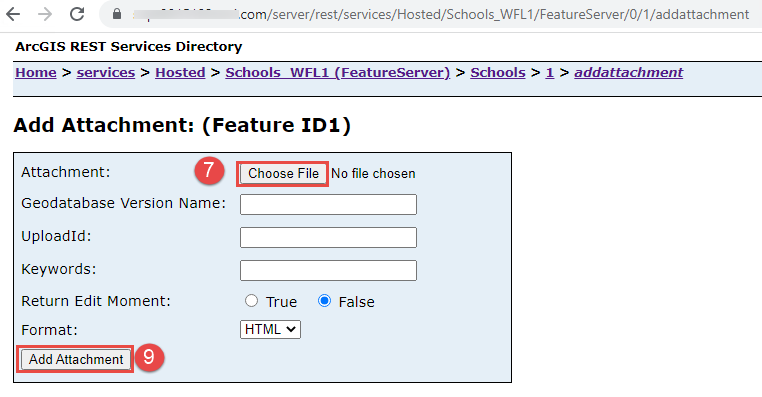
- Na página Adicionar Anexo: (ID da Feição<ID da Feição>), para Anexo, clique em Escolher Arquivo.
- Procure e selecione a imagem a ser anexada à feição. Clique em Abrir.
- Clique em Adicionar anexo.
ID do Artigo: 000029873
Obtenha suporte com IA
Resolva seu problema rapidamente com o chatbot de IA de suporte da Esri.


Informações Relacionadas
Descubra mais sobre este tema
Search for related information
Find training related to this topic
Explore ideas and give feedback
Obtenha ajuda de especialistas do ArcGIS
Comece a conversar agora