GIS A até Z| Explore este guia relacionado, apresentando termos e gráficos atualizados e desenvolvido em coordenação com a equipe do Dicionário GIS da Esri.
Saiba mais sobre GIS de A até Z
Dicionário GIS
Procurar dicionário
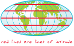
latitude
URL copiadaCompartilhar URL
[geodésia, medição]
A localização de um ponto na superfície da Terra, expressa como uma medida angular em graus, minutos e segundos ao norte ou ao sul do equador. Linhas de latitude também são denominadas de paralelos.