固定ダイアログ バー | サポート | GIS 用語集
GIS 完全ガイド |
Esri の GIS 用語集チームと連携して開発された、最新の用語と図解を収録した関連ガイドをご覧ください。
GIS 完全ガイドの詳細
GIS 用語集
用語集の参照
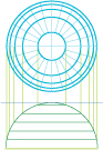
正射図法
URL がコピーされました
URL の共有
[地図投影]
投影用擬似地球から無限遠の光源に基づく、すべての光線が平行である平面図法。遠くの惑星から地球を観たときの様子。
[地図投影]
地球が自然かつ正確に表現された地図投影法。