PROCÉDURE
ajouter des pièces jointes volumineuses à une entité à l’aide du répertoire des services REST d’ArcGIS
Résumé
Les données non géographiques, comme des documents, des images et des vidéos, peuvent être associées à une entité sur une carte en tant que pièces jointes. Il est possible d’ajouter des pièces jointes à une entité dans ArcGIS Pro, Portal for ArcGIS,, ArcGIS Online et ArcGIS Field Maps. Toutefois, certains produits Esri, tels que ArcGIS Online, limitent la taille du fichier joint à 10 Mo.
Une autre solution consiste à ajouter des pièces jointes via le répertoire des services REST d’ArcGIS. Par défaut, le répertoire des services REST d’ArcGIS permet d’ajouter aux entités des pièces jointes d’une taille maximale de 2 Go. Reportez-vous à la section ArcGIS REST API : Téléchargements pour obtenir des instructions sur l’augmentation de la limite de chargement.
Procédure
Note:
Ensure the layer allows attachments before adding them. Allow attachments in ArcGIS Pro using the Enable Attachments tool before sharing the layer as a web layer. Refer to ArcGIS Pro: Enable attachments for instructions.

Alternatively, attachments can also be enabled for features in Portal for ArcGIS. Refer to Portal for ArcGIS: Allow attachments for instructions.
- Accédez au répertoire des services REST d’ArcGIS et connectez-vous à l’aide de l’URL suivante :
http://webadaptorhost.domain.com/webadaptorname/rest
- Sous Folders (Dossiers), accédez au dossier dans lequel le service d’entités hébergé est stocké.
- Sous Services, cliquez sur la couche d’entités hébergée contenant la couche d’entités pemettant d’ajouter ajouter la pièce jointe.
- Sous Layers (Couches), sélectionnez la couche pour ajouter la pièce jointe.
- Identifiez l’ID d’entité de la couche pemettant d’ajouter la pièce jointe. L’ID d’entité est l’ID d’objet de l’entité ; il figure dans la table attributaire de la couche. Pour plus d’informations, reportez-vous à la rubrique Portal for ArcGIS : Afficher des tables (Map Viewer).
- Ajoutez l’ID d’entité et l’opération addAttachment à l’URL comme suit :
http://webadaptorhost.domain.com/webadaptorname/rest/services/<folder_name>/<feature_service>/FeatureServer/<layer_ID>/<feature_ID>/addattachment
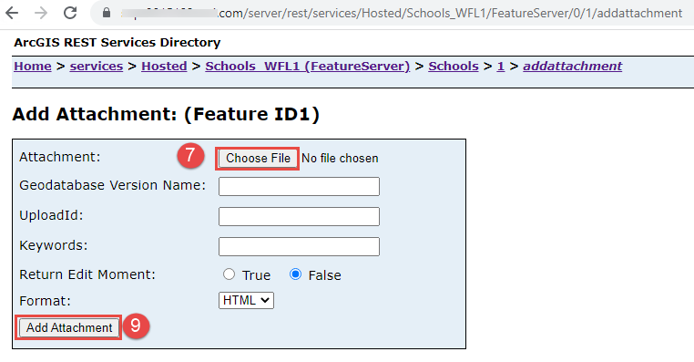
- Sur la page Add Attachment: (Feature ID<feature ID>) (Ajouter une pièce jointe : [ID d’entité <ID d’entité>]), pour Attachment (Pièce jointe), cliquez sur Choose File (Choisir un fichier).
- Accédez à l’image à joindre à l’entité et sélectionnez-la. Cliquez sur Open (Ouvrir).
- Cliquez sur Add Attachement (Ajouter une pièce jointe).
ID d’article: 000029873
Obtenez de l'aide avec l'IA
Résolvez rapidement votre problème avec le chatbot Esri Support AI.


Informations associées
En savoir plus sur ce sujet
Search for related information
Find training related to this topic
Explore ideas and give feedback
Obtenir de l’aide auprès des experts ArcGIS
Commencez à discuter maintenant