CÓMO
Dividir un polígono por porcentaje a través de ArcPy en ArcGIS Pro
Descripción
ArcGIS Pro permite dividir una entidad poligonal en varios segmentos utilizando herramientas como la herramienta Dividir (Análisis) y la herramienta Dividir del panel Modificar entidades. Sin embargo, las herramientas proporcionadas no pueden dividir el polígono por porcentaje. Siga los pasos que se proporcionan en este artículo para dividir un polígono por porcentaje en la ventana de Python.
Solución o solución alternativa
Note:
Ensure the data added to the map and the map share the same projected coordinate system to avoid errors.
- Importe el módulo de ArcPy y configure el entorno del script.
Import arcpy
p = arcpy.mp.ArcGISProject("CURRENT")
m = p.listMaps("<Map_Name>")[0]
lyr = m.listLayers(0)
- Especifique el porcentaje de división del polígono con un parámetro de matriz. En este ejemplo, el polígono se divide en un 20%, 30% y 50%.
splits = [20, 30, 50]
- Recupere las propiedades del polígono y de la extensión del polígono utilizando la función SearchCursor.
with arcpy.da.SearchCursor("<Layer_Name>", ["SHAPE@"]) as pcursor:
   for prow in pcursor:
      polygon = prow[0]    # polygon to cut
      e = polygon.extent   # bounding extent of polygon
      print(e.XMin,e.YMin,e.XMax,e.YMax)
del pcursor
- Cree una variable para almacenar el valor de precisión de la iteración geométrica.
stepsize = 0.001
- Especifique los parámetros para establecer la dirección de división del polígono.
leftXstart = e.XMin
leftX = e.XMin + stepsize
ymax = e.YMax
ymin = e.YMin
- Recorra en iteración el proceso de corte del polígono utilizando la función cut() de acuerdo con los porcentajes de división definidos en el paso 2.
cutpoly = polygon
icursor = arcpy.da.InsertCursor("<Layer_Name>", ["SHAPE@"])
for i in splits[:2]:
   print(i)
   tol = 0
   while tol < i:
      # construct NS line
      pntarray = arcpy.Array()
      pntarray.add(arcpy.Point(leftX, ymax))
      pntarray.add(arcpy.Point(leftX, ymin))
      pline = arcpy.Polyline(pntarray,arcpy.SpatialReference(<WKID>))
      # cut polygon and get split-parts
      cutlist = cutpoly.cut(pline)
      tol = 100 * cutlist[1].area / polygon.area
      leftX += stepsize
      #print str(leftX) + ":" + str(tol)
   cutpoly = cutlist[0]
   icursor.insertRow([cutlist[1]])
# part 0 is on the right and part 1 is on the left of the split
- Inserte el último resto de la división.
icursor.insertRow([cutlist[0]])
del icursor
El código que aparece a continuación muestra todo el script en marcha.
Import arcpy
p = arcpy.mp.ArcGISProject("CURRENT")
m = p.listMaps("Map")[0]
lyr = m.listLayers(0)
splits = [20, 30, 50]
with arcpy.da.SearchCursor("testpolygon", ["SHAPE@"]) as pcursor:
   for prow in pcursor:
      polygon = prow[0]
      e = polygon.extent
      print(e.XMin,e.YMin,e.XMax,e.YMax)
del pcursor
stepsize = 0.001
leftXstart = e.XMin
leftX = e.XMin + stepsize
ymax = e.YMax
ymin = e.YMin
cutpoly = polygon
icursor = arcpy.da.InsertCursor("testpolygon", ["SHAPE@"])
for i in splits[:2]:
   print(i)
   tol = 0
   while tol < i:
      pntarray = arcpy.Array()
      pntarray.add(arcpy.Point(leftX, ymax))
      pntarray.add(arcpy.Point(leftX, ymin))
      pline = arcpy.Polyline(pntarray,arcpy.SpatialReference(3857))
      cutlist = cutpoly.cut(pline)
      tol = 100 * cutlist[1].area / polygon.area
      leftX += stepsize
   cutpoly = cutlist[0]
   icursor.insertRow([cutlist[1]])
icursor.insertRow([cutlist[0]])
del icursor
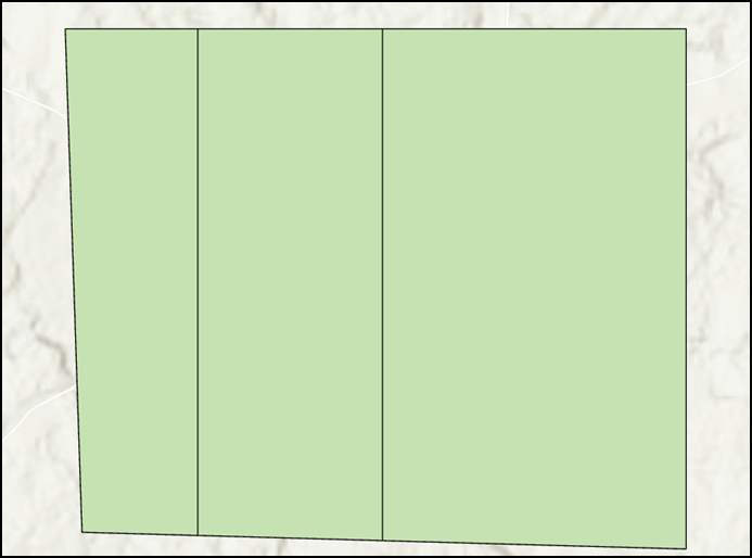
La siguiente imagen muestra el polígono dividido en un 20%, 30% y 50% después de ejecutar el script de Python en ArcGIS Pro.
Id. de artículo: 000027999
Obtenga soporte con IA
Resuelva su problema rápidamente con el chatbot de inteligencia artificial de soporte de Esri.


Información relacionada
Descubrir más sobre este tema
Search for related information
Find training related to this topic
Explore ideas and give feedback
Obtener ayuda de expertos en ArcGIS
Empieza a chatear ahora